
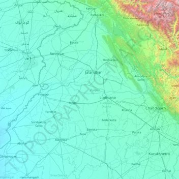
Punjab topographic map
Interactive map
Click on the map to display elevation.
About this map
Name: Punjab topographic map, elevation, terrain.
Location: Punjab, India (29.54294 73.87983 32.51118 76.93906)
Average elevation: 477 m
Minimum elevation: 170 m
Maximum elevation: 6,027 m
Punjab is in northwestern India and has a total area of 50,362 square kilometres (19,445 sq mi). Punjab is bounded by Pakistan on the west, Jammu and Kashmir on the north, Himachal Pradesh on the northeast and Haryana and Rajasthan on the south. Most of the Punjab lies in a fertile, alluvial plain with many rivers and an extensive irrigation canal system. A belt of undulating hills extends along the northeastern part of the state at the foot of the Himalayas. Its average elevation is 300 metres (980 ft) above sea level, with a range from 180 metres (590 ft) in the southwest to more than 500 metres (1,600 ft) around the northeast border. The southwest of the state is semiarid, eventually merging into the Thar Desert. The Shiwalik Hills extend along the northeastern part of the state at the foot of the Himalayas.
Other topographic maps
Click on a map to view its topography, its elevation and its terrain.
Vidyaranyapura
India > Karnataka > Yelahanka taluku > Bengaluru
Vidyaranyapura, Yelahanka Zone, Bengaluru, Yelahanka taluku, Bengaluru Urban District, Karnataka, 560097, India
Average elevation: 920 m
Vidyaranyapura
India > Karnataka > Sringeri taluku
Vidyaranyapura, Sringeri taluku, Chikkamagaluru District, Karnataka, 577592, India
Average elevation: 654 m
Vaderahalli
India > Karnataka > Chikkanayakanahalli taluk
Vaderahalli, Chikkanayakanahalli taluk, Tumakuru District, Karnataka, 572214, India
Average elevation: 784 m
Kolapur
India > Madhya Pradesh > Lateri Tahsil
Kolapur, Lateri Tahsil, Vidisha District, Madhya Pradesh, India
Average elevation: 520 m
Gandipet mandal
Gandipet mandal, Ranga Reddy District, Telangana, India
Average elevation: 559 m
Sela-Pass
India > Arunachal Pradesh > Dirang ADC
Sela-Pass, Dirang ADC, West Kameng District, Arunachal Pradesh, India
Average elevation: 4,073 m
Senge
India > Arunachal Pradesh > Dirang ADC
Senge, Dirang ADC, West Kameng District, Arunachal Pradesh, India
Average elevation: 3,055 m
Lingshed
India > Ladakh > Khalsi tehsil
Lingshed, Khalsi tehsil, Leh District, Ladakh, India
Average elevation: 4,209 m
Bomdila
India > Arunachal Pradesh > Bomdila HQ
Bomdila, Bomdila HQ, West Kameng District, Arunachal Pradesh, India
Average elevation: 2,033 m
Dirang
India > Arunachal Pradesh > Dirang ADC
Dirang, Dirang ADC, West Kameng District, Arunachal Pradesh, India
Average elevation: 2,000 m
New Friends Colony
India > Delhi > Defence Colony Tehsil
New Friends Colony, Defence Colony Tehsil, South East Delhi District, Delhi, India
Average elevation: 212 m
Jaggayapeta
India > Andhra Pradesh > Vepada
Jaggayapeta, Vepada, Vizianagaram District, Andhra Pradesh, 535161, India
Average elevation: 62 m
Bhandara City
India > Maharashtra > Bhandara Taluka
Bhandara City, Bhandara Taluka, Bhandara, Maharashtra, India
Average elevation: 252 m
Bhongir
India > Telangana > Bhongiri mandal
Bhongir, Bhongiri mandal, Yadadri Bhuvanagiri District, Telangana, 508100, India
Average elevation: 447 m
Ibrahim Bagh
India > Telangana > Gandipet mandal > Hyderabad
Ibrahim Bagh, Hyderabad, Gandipet mandal, Ranga Reddy District, Telangana, 500031, India
Average elevation: 527 m
Bhojwasa
India > Uttarakhand > Bhatwari
Bhojwasa, Bhatwari, Uttarkashi district, Uttarakhand, India
Average elevation: 4,263 m
Kadayanallur
India > Tamil Nadu > Tenkasi > Kadayanallur
Kadayanallur, Tenkasi, Tenkasi District, Tamil Nadu, 627751, India
Average elevation: 197 m
Chengannur
India > Kerala > Chengannur > Chengannur
Chengannur, Alappuzha, Kerala, 689121, India
Average elevation: 13 m
Sriperumbudur
Sriperumbudur, Kanchipuram District, Tamil Nadu, India
Average elevation: 48 m
Dharavi
India > Maharashtra > Mumbai
Dharavi, Zone 2, Mumbai, Mumbai City, Maharashtra, India
Average elevation: 6 m
Dobola
India > Himachal Pradesh > Dobola
Dobola, Chamba, Himachal Pradesh, 176314, India
Average elevation: 1,408 m
Kangsabati River
Kangsabati River, Sarenga, Bankura, West Bengal, India
Average elevation: 100 m
Udhagamandalam
India > Tamil Nadu > Udhagamandalam
Udhagamandalam, The Nilgiris, The Nilgiris district, Tamil Nadu, 643001, India
Average elevation: 2,234 m
Chinchwad
India > Maharashtra > Chinchwad
Chinchwad, Kolhapur, Maharashtra, 416112, India
Average elevation: 548 m
Tiwariganj
India > Uttar Pradesh > Tiwariganj
Tiwariganj, Lucknow, Uttar Pradesh, India
Average elevation: 117 m
Palia
India > Uttar Pradesh > Palia
Palia, Kheri, Uttar Pradesh, 262902, India
Average elevation: 157 m
Panthaghatti
India > Himachal Pradesh > Panthaghatti
Panthaghatti, Solan, Himachal Pradesh, 171009, India
Average elevation: 1,746 m