
Sela-Pass topographic map
Interactive map
Click on the map to display elevation.
About this map
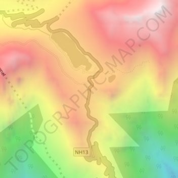
Name: Sela-Pass topographic map, elevation, terrain.
Average elevation: 4,073 m
Minimum elevation: 3,180 m
Maximum elevation: 4,745 m
The Sela Pass (more appropriately called Se La, as La means Pass) is a high-altitude mountain pass located on the border between the Tawang and West Kameng districts in the Indian state of Arunachal Pradesh. It has an elevation of 4170 m (13,700 ft) and connects the Indian Buddhist town of Tawang to Dirang and Guwahati. The pass carries the National Highway 13 (previously NH 229), connecting Tawang with the rest of India. The pass supports scarce amounts of vegetation and is usually snow-covered to some extent throughout the year. Sela Lake, near the summit of the pass, is one of approximately 101 lakes in the area that are sacred in Tibetan Buddhism. While Sela Pass does get heavy snowfall in winters, it is usually open throughout the year unless landslides or snow require the pass to be shut down temporarily. Sela pass is one of the highest motorable mountain passes in the world
Other topographic maps
Click on a map to view its topography, its elevation and its terrain.
Senge
India > Arunachal Pradesh > Dirang ADC
Senge, Dirang ADC, West Kameng District, Arunachal Pradesh, India
Average elevation: 3,055 m
Dirang
India > Arunachal Pradesh > Dirang ADC
Dirang, Dirang ADC, West Kameng District, Arunachal Pradesh, India
Average elevation: 2,000 m