
Amreli topographic map
Interactive map
Click on the map to display elevation.
About this map
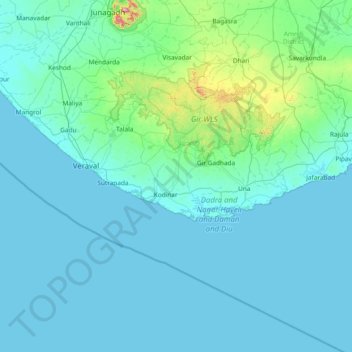
Name: Amreli topographic map, elevation, terrain.
Location: Amreli, Gir Somnath District, Gujarat, 362710, India (20.22667 70.11000 21.50667 71.39000)
Average elevation: 62 m
Minimum elevation: -1 m
Maximum elevation: 889 m
Other topographic maps
Click on a map to view its topography, its elevation and its terrain.