
Thank you for supporting this site ❤️
Make a donation
Make a donation
Gandipet mandal topographic map
Click on the map to display elevation.
Thank you for supporting this site ❤️
Make a donation
Make a donation
About this map
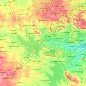
Name: Gandipet mandal topographic map, elevation, terrain.
Location: Gandipet mandal, Ranga Reddy District, Telangana, India (17.32791 78.22810 17.43418 78.42037)
Average elevation: 559 m
Minimum elevation: 494 m
Maximum elevation: 631 m
Thank you for supporting this site ❤️
Make a donation
Make a donation
Other topographic maps
Click on a map to view its topography, its elevation and its terrain.
Bhongir
India > Telangana > Bhongiri mandal
Bhuvanagiri is located at 17°30′39″N 78°53′20″E / 17.5108°N 78.8889°E / 17.5108; 78.8889. It has an average elevation of 329 metres (1,079 ft).
Average elevation: 447 m