
Make a donation
Albania topographic map
Click on the map to display elevation.
Make a donation
Albania
Divjakë-Karavasta National Park extends along the central Albanian Adriatic Sea Coast and possesses one of the largest lagoons in the Mediterranean Sea, the Lagoon of Karavasta. The Ceraunian Mountains in southern Albania, rising immediately along the Albanian Ionian Sea Coast, characterises the topographical picture of Llogara National Park and continue on the Peninsula of Karaburun within the Karaburun-Sazan Marine Park. Further south sprawls the Butrint National Park on a peninsula that is surrounded by the Lake of Butrint and Channel of Vivari on the eastern half of the Straits of Corfu. Dajti National Park is equipped with a cable car and trails to some spectacular scenery is a popular retreat in the capital, Tirana.
Make a donation
About this map
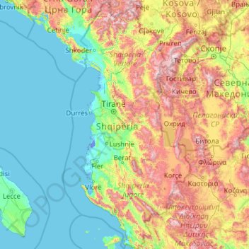
Name: Albania topographic map, elevation, terrain.
Location: Albania (39.64039 19.00099 42.66108 21.05743)
Average elevation: 522 m
Minimum elevation: -7 m
Maximum elevation: 2,633 m
Make a donation
Other topographic maps
Click on a map to view its topography, its elevation and its terrain.
Bulawayo
Zimbabwe > Bulawayo Province > Bulawayo
Due to its relatively high altitude, the city has a humid subtropical climate despite lying in the tropics. Under the Köppen climate classification, Bulawayo features a semiarid climate (BSh). The mean annual temperature is 19.16 °C (66.49 °F), similar to Pretoria at a similar altitude but almost 600 km…
Average elevation: 1,348 m
Gwanda
Zimbabwe > Matabeleland South Province > Gwanda
The town is located 134 kilometres (83 mi), by road, south east of the city of Bulawayo, Zimbabwe's second largest city. This location lies on the Bulawayo–Beitbridge Road and the Beitbridge Bulawayo Railway. The town of Beitbridge, at Zimbabwe's border with the Republic of South Africa, lies approximately…
Average elevation: 1,012 m
Make a donation
Mutare
Zimbabwe > Manicaland Province > Mutare
Despite its tropical location, the city has a humid subtropical climate, of the highland variety moderated by its altitude. Mutare experiences drizzle almost throughout the year. The average annual temperature is 19 °C, surprisingly low for its moderate altitude (about the same as Harare which is 360 metres…
Average elevation: 1,160 m
Victoria Falls
Zimbabwe > Matabeleland North Province > Hwange > Victoria Falls Municipality
Average elevation: 918 m
Make a donation
Chinhoyi
Zimbabwe > Mashonaland West Province > Makonde
The geographical coordinates of Chinhoyi are:17°20'59.0"S, 30°11'40.0"E (Latitude:-17.349722; Longitude:30.194444). Chinhoyi sits at an average elevation of 1,187 metres (3,894 ft) above mean sea level.
Average elevation: 1,167 m
Make a donation
Kariba
Zimbabwe > Mashonaland West Province > Kariba
Kariba has a tropical savanna climate (Köppen climate classification Aw), with warm winters and very hot summers, and a marked drier season in the winter. Although it is relatively cooler than typical tropical places in the winter and does get occasional 5 °C (41 °F) lows, Kariba nevertheless meets the…
Average elevation: 550 m
Make a donation
Beitbridge
Zimbabwe > Matabeleland South Province > Beitbridge > Municipality of Beitbridge
Average elevation: 479 m
Make a donation
Make a donation
Make a donation
Kadoma
Zimbabwe > Mashonaland West Province > Kadoma
The city is located in Kadoma District, Mashonaland West Province, one of the 10 administrative provinces in Zimbabwe. This location lies approximately 141 kilometres (88 mi), by road, southwest of Harare, the national capital and largest city in the country. The city lies on Highway A-5, between Harare and…
Average elevation: 1,134 m
Make a donation
Hwange
Zimbabwe > Matabeleland North Province > Hwange
Hwange (formerly Wankie) is a town in Zimbabwe, located in Hwange District, in Matabeleland North Province, in northwestern Zimbabwe, close to the international borders with Botswana and Zambia. It lies approximately 100 kilometres (62 mi), by road, southeast of Victoria Falls, the nearest large city. The town…
Average elevation: 774 m
Make a donation
Kwekwe
Zimbabwe > Midlands Province > Kwekwe
The town is situated on Zimbabwe's Highveld at an altitude of 1,220 metres (4,000 ft), above sea level. It is located in the tropics but its high altitude modifies this to a warm temperate or humid subtropical climate.
Average elevation: 1,200 m
Make a donation
Harare
Harare (/həˈrɑːreɪ/ hə-RAR-ay), originally known as Salisbury (/ˈsɔːlzbəri/ SAWLZ-bər-ee), is the capital and most populous city of Zimbabwe. The city proper has an area of 940 km2 (371 mi2) a population of 2.12 million in the 2012 census and an estimated 3.12 million in its metropolitan area in…
Average elevation: 1,470 m
Africa
Average elevation: 462 m
Make a donation
Make a donation
Jersey
Jersey is an island measuring 118.2 square kilometres (45.6 sq mi) (or 66,436 vergées), including reclaimed land and intertidal zone. It lies in the English Channel, about 12 nautical miles (22 km; 14 mi) from the Cotentin Peninsula in Normandy, France, and about 87 nautical miles (161 km; 100 mi) south of…
Average elevation: 145 m
Make a donation
Thebes
Greece > Central Greece > Regional Unit of Boeotia > Municipal Unit of Thebes
Thebes is situated in a plain, between Lake Yliki (ancient Hylica) to the north, and the Cithaeron mountains, which divide Boeotia from Attica, to the south. Its elevation is 215 m (705 ft) above mean sea level. It is about 50 km (31 mi) northwest of Athens, and 100 km (62 mi) southeast of Lamia. The A1…
Average elevation: 218 m
Make a donation
Make a donation
Mpuluzi
South Africa > Mpumalanga > Gert Sibande > Albert Luthuli Local Municipality
Average elevation: 1,458 m
Gibson Desert
The Gibson Desert is located between the saline Kumpupintil Lake and Lake Macdonald along the Tropic of Capricorn, south of the Great Sandy Desert, east of the Little Sandy Desert, and north of the Great Victoria Desert. The altitude rises to just above 500 metres (1,600 ft) in places. As noted by early…
Average elevation: 464 m
Make a donation
Germiston
South Africa > Gauteng > City of Ekurhuleni Metropolitan Municipality
Average elevation: 1,635 m
Make a donation
Mieso
Mieso (Oromo: Mi'eesso) is a town in eastern Ethiopia. Located in the WEST OROMIA of the OROMIA Region, it has a latitude and longitude of 9°14′N 40°45′E / 9.233°N 40.750°E / 9.233; 40.750 with an elevation of 1394 meters above sea level.
Average elevation: 1,369 m
Make a donation
Karoo
South Africa > Western Cape > Central Karoo District Municipality > Beaufort West Local Municipality
The Karoo (/kəˈruə/ kə-ROO-ə; from Khoikhoi (also known as Khoekhoegowab/Namagowab or Hottentot language) word Karo (Korana for 'Hardveld')) is a semidesert natural region of South Africa. No exact definition of what constitutes the Karoo is available, so its extent is also not precisely defined. The…
Average elevation: 881 m
Soweto
South Africa > Gauteng > City of Johannesburg Metropolitan Municipality
Average elevation: 1,638 m
Algiers
Algeria > Algiers > Sidi M'Hamed District > Alger-Centre
The city's downtown sits at an elevation of 2 m (at the Algiers Central Post Office), while it averages 45 m across the city's metropolitan area, and tops at 407 m on the Bouzaréah peak. Algiers Province, the administrative area that includes the city's urban and suburban centers covers 1,190 km2 (460 sq mi).
Average elevation: 45 m
Make a donation
Queen Valley
United States > Arizona > Pinal County
Queen Valley is located at 33°17′42″N 111°17′52″W / 33.29500°N 111.29778°W / 33.29500; -111.29778, at an elevation of 2000 feet along the south side of the west flowing Queen Creek. The Tonto National Forest boundary and Comet Peak (2681 ft.) lie 1.5 miles to the east. The dam for the…
Average elevation: 633 m
Nxuba
South Africa > Eastern Cape > Chris Hani District Municipality > Inxuba Yethemba Local Municipality
Average elevation: 940 m
Make a donation
Make a donation
Alice
South Africa > Eastern Cape > Amathole District Municipality > Nkonkobe Local Municipality
The location was named Lovedale by European missionaries who settled there in 1824. It lies on the southwestern bank of the Tyhume River, west-northwest of East London, at an elevation of 1,720(524m). It was named after John Love of the Glasgow Missionary Society. During the Frontier War it was abandoned and…
Average elevation: 586 m
Pretoria
South Africa > Gauteng > City of Tshwane Metropolitan Municipality
Pretoria is situated approximately 56 km (35 mi) north-northeast of Johannesburg in the northeast of South Africa, in a transitional belt between the plateau of the Highveld to the south and the lower-lying Bushveld to the north. It lies at an altitude of about 1,339 m (4,393 ft) above sea level, in a warm,…
Average elevation: 1,363 m
Make a donation
Make a donation
Vienna Basin
Austria > Lower Austria > Bezirk Mistelbach > Bockfließ
The Vienna Basin (German: Wiener Becken, Czech: Vídeňská pánev, Slovak: Viedenská kotlina, Hungarian: Bécsi-medence) is a geologically young tectonic burial basin and sedimentary basin in the seam area between the Alps, the Carpathians and the Pannonian Plain. Although it topographically separates the…
Average elevation: 166 m
Make a donation
Make a donation