
Hwange topographic map
Interactive map
Click on the map to display elevation.
Hwange
Hwange (formerly Wankie) is a town in Zimbabwe, located in Hwange District, in Matabeleland North Province, in northwestern Zimbabwe, close to the international borders with Botswana and Zambia. It lies approximately 100 kilometres (62 mi), by road, southeast of Victoria Falls, the nearest large city. The town lies on the railway line from Bulawayo, Zimbabwe's second-largest city, to Victoria Falls. Hwange sits at an elevation of 770 metres (2,530 ft), above sea level.
About this map
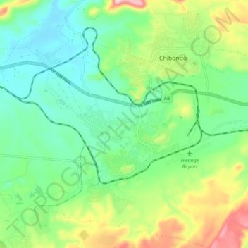
Name: Hwange topographic map, elevation, terrain.
Location: Hwange, Matabeleland North Province, Zimbabwe (-18.39291 26.45870 -18.31291 26.53870)
Average elevation: 774 m
Minimum elevation: 695 m
Maximum elevation: 945 m
Other topographic maps
Click on a map to view its topography, its elevation and its terrain.
Devil's Cataract
Zimbabwe > Matabeleland North Province > Hwange > Victoria Falls
Average elevation: 884 m
Victoria Falls
Zimbabwe > Matabeleland North Province > Hwange > Victoria Falls
Average elevation: 881 m
Victoria Falls
Zimbabwe > Matabeleland North Province > Hwange > Victoria Falls
Average elevation: 881 m
Batoka Gorge
Zimbabwe > Matabeleland North Province > Hwange > Victoria Falls
Average elevation: 861 m