
Make a donation
South America topographic map
Click on the map to display elevation.
Make a donation
South America
South America's topography is marked by remarkable diversity and dramatic contrasts. The continent is dominated by the Andes mountain range, which runs along its western edge, stretching over 4,300 miles from Venezuela to Chile. These mountains are home to some of the highest peaks in the Western Hemisphere, including Aconcagua, which rises to 22,841 feet. To the east of the Andes lies the expansive Amazon Basin, encompassing nearly 2.7 million square miles and characterized by dense rainforests that are teeming with biodiversity. The basin is fed by numerous tributaries, including the mighty Amazon River, which discharges vast volumes of water into the Atlantic Ocean. Meanwhile, the eastern regions feature the fertile Pampas, a vast grassland ideal for agriculture, and the semi-arid regions of Patagonia, known for its rugged terrain and sparse rainfall due to the rain shadow effect of the Andes. Notably, the Atacama Desert, situated along the Pacific coast, is recognized as the driest non-polar desert in the world, showcasing the continent's extreme climatic conditions and geographical variety.
Make a donation
About this map
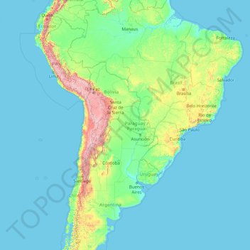
Name: South America topographic map, elevation, terrain.
Location: South America (-46.00022 -86.00066 3.99978 -36.00066)
Average elevation: 283 m
Minimum elevation: -1 m
Maximum elevation: 6,497 m
Make a donation
Other topographic maps
Click on a map to view its topography, its elevation and its terrain.
Zimbabwe
Zimbabwe is a landlocked country in southern Africa, lying between latitudes 15° and 23°S, and longitudes 25° and 34°E. It is bordered by South Africa to the south, Botswana to the west and southwest, Zambia to the northwest, and Mozambique to the east and northeast. Its northwest corner is roughly 150…
Average elevation: 869 m
Make a donation
Bulawayo Province
Under the Köppen climate classification, Bulawayo features a hot semi-arid climate (BSh). Due to its relatively high altitude, the city has fairly moderate temperatures despite lying in the tropics. The mean annual temperature is 19.16 °C (66.49 °F), similar to Pretoria at a similar altitude but almost 600…
Average elevation: 1,321 m
Make a donation
Make a donation
Make a donation
Make a donation
Make a donation
Goromonzi
Zimbabwe > Mashonaland East Province
Three medical clinics are available for the community. Resources are strained to serve such a wide area; and some people have to walk 19 kilometres (12 mi) or more to get care. Although malaria is not a serious problem due to Goromonzi’s altitude, schistosomiasis (bilharzia) is widespread and goes untreated,…
Average elevation: 1,396 m
Make a donation
Germany
Germany is the seventh-largest country in Europe. It borders Denmark to the north, Poland and the Czech Republic to the east, Austria and Switzerland to the south, and France, Luxembourg, Belgium, and the Netherlands to the west. Germany is also bordered by the North Sea and, at the north-northeast, by the…
Average elevation: 237 m
Make a donation
United Arab Emirates
The climate of the UAE is subtropical-arid with hot summers and warm winters. The climate is categorised as desert climate. The hottest months are July and August, when average maximum temperatures reach above 45 °C (113 °F) on the coastal plain. In the Hajar Mountains, temperatures are considerably lower, a…
Average elevation: 85 m
Make a donation
Make a donation
Make a donation
Kaş
As the tenth most populous district of Antalya as of 2022, Kaş is on a hill running down to the Turquoise Coast of southwestern Turkey. The district has a typical Mediterranean climate of hot, dry summers and mild, wet winters, which allows the growth of oranges, lemons and bananas. The lowland areas are also…
Average elevation: 837 m
Make a donation
KwaZulu-Natal
KwaZulu-Natal has a varied yet verdant climate thanks to diverse, complex topography. Generally, the coast is subtropical with inland regions becoming progressively colder. Durban on the south coast has an annual rainfall of 1009 mm, with daytime maxima peaking from January to March at 28 °C (82 °F) with a…
Average elevation: 777 m
Ethiopia
In 2019, archaeologists discovered a 30,000-year-old Middle Stone Age rock shelter at the Fincha Habera site in Bale Mountains at an elevation of 3,469 metres (11,381 feet) above sea level. At this high altitude, humans are susceptible both to hypoxia and to extreme weather. According to a study published in…
Average elevation: 846 m
Make a donation
Make a donation
Detroit
United States > Michigan > Wayne County
The city slopes gently from the northwest to southeast on a till plain composed largely of glacial and lake clay. The most notable topographical feature in the city is the Detroit Moraine, a broad clay ridge on which the older portions of Detroit and Windsor are located, rising approximately 62 feet (19 m)…
Average elevation: 187 m
Make a donation
Italy
Conditions on the coast are different from those in the interior, particularly during winter when the higher altitudes tend to be cold, wet, and often snowy. The coastal regions have mild winters, and hot and generally dry summers; lowland valleys are hot in summer. Winter temperatures vary from 0 °C (32 °F)…
Average elevation: 293 m
Bağcılar
Bağcılar is located on the European side of Istanbul, within the service boundaries of Istanbul Metropolitan Municipality. Its area is 22 km2 (8.5 sq mi). The district is now known as an immigrant quarter. It lies between E-5 and TEM. In the south Bahçelievler, in the west Küçükçekmece, in the northwest…
Average elevation: 85 m
Make a donation
Kiribati
Average elevation: 384 m
Newton
United States > New Jersey > Sussex County
Because of its location in the higher elevations of northwestern New Jersey's Appalachian mountains, Newton, as well as the rest of Sussex County, has a cooler humid continental climate or microthermal climate (Köppen climate classification Dfb) which indicates patterns of significant precipitation in all…
Average elevation: 202 m
Albania
Divjakë-Karavasta National Park extends along the central Albanian Adriatic Sea Coast and possesses one of the largest lagoons in the Mediterranean Sea, the Lagoon of Karavasta. The Ceraunian Mountains in southern Albania, rising immediately along the Albanian Ionian Sea Coast, characterises the topographical…
Average elevation: 522 m
Make a donation
Mpuluzi
South Africa > Mpumalanga > Gert Sibande > Albert Luthuli Local Municipality
Average elevation: 1,458 m
Japan
Average elevation: 58 m
Make a donation
Wales
Wales is predominantly mountainous, with its terrain shaped by ancient geological processes and glaciation. In the north, Snowdonia (Eryri) boasts the country's highest peaks, including Snowdon (Yr Wyddfa) at 1,085 meters (3,560 feet). Central Wales is characterized by the Cambrian Mountains, featuring…
Average elevation: 99 m
Las Vegas
United States > Nevada > Clark County
The city's elevation is approximately 2,030 ft (620 m) above sea level, though the surrounding peaks reach elevations of over 10,000 feet (3,000 m) and act as barriers to the strong flow of moisture from the surrounding area. According to the United States Census Bureau, the city has an area of 135.86 sq mi…
Average elevation: 756 m
Make a donation
Make a donation
Poland
The native Polish name for Poland is Polska. It is believed that the name derives from the Polans, a West Slavic tribe who inhabited the Warta River basin of present-day Greater Poland region (6th–8th century CE). The tribe's name stems from the Proto-Slavic noun pole meaning field, which itself originates…
Average elevation: 194 m
Saudi Arabia
Saudi Arabia's geography is dominated by the Arabian Desert, associated semi-desert and shrubland (see satellite image) and several mountain ranges and highlands. It is, in fact, a number of linked deserts and includes the 647,500 km2 (250,001 sq mi) Rub' al Khali ("Empty Quarter") in the southeastern part of…
Average elevation: 551 m
Chiang Mai City Municipality
Thailand > Mueang Chiang Mai District
The city is situated in a broad basin in the Thai highlands and lies at an average elevation of 300 m (1,000 ft) elevation above sea level. Chiang Mai's city centre sits west of the Ping River, a tributary to the Chao Phraya River. The city's sprawl extends outward in all directions, especially north, south,…
Average elevation: 325 m
Make a donation
Make a donation
Seattle
United States > Washington > King County
The city is hilly in some places. Like Rome, the city is said to lie on seven hills; the lists vary but typically include Capitol Hill, First Hill, West Seattle, Beacon Hill, Queen Anne, Magnolia, and the former Denny Hill. The Wallingford, Delridge, Mount Baker, Seward Park, Washington Park, Broadmoor,…
Average elevation: 40 m
Make a donation
Taal Lake
Taal Lake was once an inlet of nearby Balayan Bay, and was easily navigable from it. A series of major eruptions in the early 18th century battered the lakeside towns with earthquakes and volcanic debris.[7] The activity culminated in 1754 with Taal Volcano's largest eruption that blocked Pansipit River with…
Average elevation: 104 m
Iran
Iran's topography is diverse and dominated by rugged mountain ranges, which define much of its landscape. To the west, the Zagros Mountains stretch from the northwest to the southeast, with many peaks surpassing 10,000 feet (3,048 meters) in elevation. These mountains form a rugged barrier between Iran's…
Average elevation: 786 m
Make a donation
Botswana
Botswana, officially the Republic of Botswana, is a landlocked country in Southern Africa. Botswana is topographically flat, with approximately 70 percent of its territory being the Kalahari Desert. It is bordered by South Africa to the south and southeast, Namibia to the west and north, Zambia to the north…
Average elevation: 1,078 m
Make a donation