
Make a donation
Zimbabwe topographic map
Click on the map to display elevation.
Make a donation
Zimbabwe
Zimbabwe is a landlocked country in southern Africa, lying between latitudes 15° and 23°S, and longitudes 25° and 34°E. It is bordered by South Africa to the south, Botswana to the west and southwest, Zambia to the northwest, and Mozambique to the east and northeast. Its northwest corner is roughly 150 meters from Namibia, nearly forming a four-nation quadripoint. Most of the country is elevated, consisting of a central plateau (high veld) stretching from the southwest northwards with altitudes between 1,000 and 1,600 m. The country's extreme east is mountainous, this area being known as the Eastern Highlands, with Mount Nyangani as the highest point at 2,592 m.
Make a donation
About this map
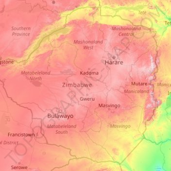
Name: Zimbabwe topographic map, elevation, terrain.
Location: Zimbabwe (-22.42411 25.23730 -15.60970 33.06835)
Average elevation: 869 m
Minimum elevation: 68 m
Maximum elevation: 2,437 m
Make a donation
Other topographic maps
Click on a map to view its topography, its elevation and its terrain.
Jersey
Jersey is an island measuring 118.2 square kilometres (45.6 sq mi) (or 66,436 vergées), including reclaimed land and intertidal zone. It lies in the English Channel, about 12 nautical miles (22 km; 14 mi) from the Cotentin Peninsula in Normandy, France, and about 87 nautical miles (161 km; 100 mi) south of…
Average elevation: 145 m
Bulawayo
Zimbabwe > Bulawayo Province > Bulawayo
Due to its relatively high altitude, the city has a humid subtropical climate despite lying in the tropics. Under the Köppen climate classification, Bulawayo features a semiarid climate (BSh). The mean annual temperature is 19.16 °C (66.49 °F), similar to Pretoria at a similar altitude but almost 600 km…
Average elevation: 1,348 m
Make a donation
Mutare
Zimbabwe > Manicaland Province > Mutare
Despite its tropical location, the city has a humid subtropical climate, of the highland variety moderated by its altitude. Mutare experiences drizzle almost throughout the year. The average annual temperature is 19 °C, surprisingly low for its moderate altitude (about the same as Harare which is 360 metres…
Average elevation: 1,160 m
Victoria Falls
Zimbabwe > Matabeleland North Province > Hwange > Victoria Falls Municipality
Average elevation: 918 m
Make a donation
Make a donation
Chinhoyi
Zimbabwe > Mashonaland West Province > Makonde
The geographical coordinates of Chinhoyi are:17°20'59.0"S, 30°11'40.0"E (Latitude:-17.349722; Longitude:30.194444). Chinhoyi sits at an average elevation of 1,187 metres (3,894 ft) above mean sea level.
Average elevation: 1,167 m
Kariba
Zimbabwe > Mashonaland West Province > Kariba
Kariba has a tropical savanna climate (Köppen climate classification Aw), with warm winters and very hot summers, and a marked drier season in the winter. Although it is relatively cooler than typical tropical places in the winter and does get occasional 5 °C (41 °F) lows, Kariba nevertheless meets the…
Average elevation: 550 m
Make a donation
Make a donation
Beitbridge
Zimbabwe > Matabeleland South Province > Beitbridge > Municipality of Beitbridge
Average elevation: 479 m
Make a donation
Make a donation
Kadoma
Zimbabwe > Mashonaland West Province > Kadoma
The city is located in Kadoma District, Mashonaland West Province, one of the 10 administrative provinces in Zimbabwe. This location lies approximately 141 kilometres (88 mi), by road, southwest of Harare, the national capital and largest city in the country. The city lies on Highway A-5, between Harare and…
Average elevation: 1,134 m
Make a donation
Hwange
Zimbabwe > Matabeleland North Province > Hwange
Hwange (formerly Wankie) is a town in Zimbabwe, located in Hwange District, in Matabeleland North Province, in northwestern Zimbabwe, close to the international borders with Botswana and Zambia. It lies approximately 100 kilometres (62 mi), by road, southeast of Victoria Falls, the nearest large city. The town…
Average elevation: 774 m
Make a donation
Gwanda
Zimbabwe > Matabeleland South Province > Gwanda
The town is located 134 kilometres (83 mi), by road, south east of the city of Bulawayo, Zimbabwe's second largest city. This location lies on the Bulawayo–Beitbridge Road and the Beitbridge Bulawayo Railway. The town of Beitbridge, at Zimbabwe's border with the Republic of South Africa, lies approximately…
Average elevation: 1,012 m
Make a donation
Kwekwe
Zimbabwe > Midlands Province > Kwekwe
The town is situated on Zimbabwe's Highveld at an altitude of 1,220 metres (4,000 ft), above sea level. It is located in the tropics but its high altitude modifies this to a warm temperate or humid subtropical climate.
Average elevation: 1,200 m
Harare
Harare (/həˈrɑːreɪ/ hə-RAR-ay), originally known as Salisbury (/ˈsɔːlzbəri/ SAWLZ-bər-ee), is the capital and most populous city of Zimbabwe. The city proper has an area of 940 km2 (371 mi2) a population of 2.12 million in the 2012 census and an estimated 3.12 million in its metropolitan area in…
Average elevation: 1,470 m
Mpuluzi
South Africa > Mpumalanga > Gert Sibande > Albert Luthuli Local Municipality
Average elevation: 1,458 m
Make a donation
Make a donation
Make a donation
Karoo
South Africa > Western Cape > Central Karoo District Municipality > Beaufort West Local Municipality
The Karoo (/kəˈruə/ kə-ROO-ə; from Khoikhoi (also known as Khoekhoegowab/Namagowab or Hottentot language) word Karo (Korana for 'Hardveld')) is a semidesert natural region of South Africa. No exact definition of what constitutes the Karoo is available, so its extent is also not precisely defined. The…
Average elevation: 881 m
Germiston
South Africa > Gauteng > City of Ekurhuleni Metropolitan Municipality
Average elevation: 1,635 m
Soweto
South Africa > Gauteng > City of Johannesburg Metropolitan Municipality
Average elevation: 1,638 m
Make a donation
Queen Valley
United States > Arizona > Pinal County
Queen Valley is located at 33°17′42″N 111°17′52″W / 33.29500°N 111.29778°W / 33.29500; -111.29778, at an elevation of 2000 feet along the south side of the west flowing Queen Creek. The Tonto National Forest boundary and Comet Peak (2681 ft.) lie 1.5 miles to the east. The dam for the…
Average elevation: 633 m
Alice
South Africa > Eastern Cape > Amathole District Municipality > Nkonkobe Local Municipality
The location was named Lovedale by European missionaries who settled there in 1824. It lies on the southwestern bank of the Tyhume River, west-northwest of East London, at an elevation of 1,720(524m). It was named after John Love of the Glasgow Missionary Society. During the Frontier War it was abandoned and…
Average elevation: 586 m
Make a donation
Make a donation
Vienna Basin
Austria > Lower Austria > Bezirk Mistelbach > Bockfließ
The Vienna Basin (German: Wiener Becken, Czech: Vídeňská pánev, Slovak: Viedenská kotlina, Hungarian: Bécsi-medence) is a geologically young tectonic burial basin and sedimentary basin in the seam area between the Alps, the Carpathians and the Pannonian Plain. Although it topographically separates the…
Average elevation: 166 m
Make a donation
Centurion
South Africa > Gauteng > City of Tshwane Metropolitan Municipality
Average elevation: 1,451 m
Make a donation
Dullstroom
South Africa > Mpumalanga > Nkangala > Emakhazeni Local Municipality
Due to its high elevation (Dullstroom being the highest town in South Africa itself), Dullstroom has a subtropical highland climate (Köppen: Cwb). From October to April, the town sees a significant amount of rainfall (higher than nearby Johannesburg to the west), in contrast with winter, where precipitation…
Average elevation: 2,009 m
Make a donation
Sabie
South Africa > Mpumalanga > Ehlanzeni District Municipality > Thaba Chweu Local Municipality
Average elevation: 1,150 m
Medina
Saudi Arabia > Medina Province
Medina is located in the Hejaz region which is a 200 km (120 mi) wide strip between the Nafud desert and the Red Sea. Located approximately 720 km (450 mi) northwest of Riyadh which is at the centre of the Saudi desert, the city is 250 km (160 mi) away from the west coast of Saudi Arabia and at an elevation of…
Average elevation: 692 m
Make a donation
Make a donation
Pretoria
South Africa > Gauteng > City of Tshwane Metropolitan Municipality
Pretoria is situated approximately 56 km (35 mi) north-northeast of Johannesburg in the northeast of South Africa, in a transitional belt between the plateau of the Highveld to the south and the lower-lying Bushveld to the north. It lies at an altitude of about 1,339 m (4,393 ft) above sea level, in a warm,…
Average elevation: 1,363 m
Make a donation
Klima
Greece > Region of Crete > Heraklion Regional Unit > Tybakio Municipal Unit
Average elevation: 176 m
Stellenbosch
South Africa > Western Cape > Cape Winelands District Municipality > Stellenbosch Local Municipality
Stellenbosch is 53 km (33 mi) east of Cape Town via National Route N1. Stellenbosch is in a hilly region of the Cape Winelands, and is sheltered in a valley at an average elevation of 136 m (446 ft), flanked on the west by Papegaaiberg (Afrikaans: Parrot Mountain), which is actually a hill. To the south is…
Average elevation: 222 m
Make a donation
Livno
Bosnia and Herzegovina > Federation of Bosnia and Herzegovina > City of Livno
Average elevation: 907 m
Tuba
Tuba's topography is generally characterized by irregular rugged terrain and steep slopes with several mountain peaks rising from the table land itself. Mount Santo Tomas, the highest peak in the municipality soars to 2,252 metres (7,388 ft) above sea level.
Average elevation: 1,242 m
Make a donation
Reineberg
Germany > North Rhine-Westphalia > Kreis Minden-Lübbecke > Lübbecke
The Reineberg is a hill on the Wiehen ridge, south of the town of Lübbecke. With a height of 275.9 m above sea level it is, from a topographical point of view, not a particularly impressive eminence in this part of the Wiehen Hills, because, in the immediate vicinity are considerably higher summits, such as…
Average elevation: 181 m
Make a donation