
Chikomba topographic map
Interactive map
Click on the map to display elevation.
About this map
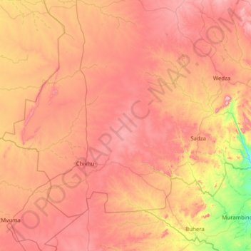
Name: Chikomba topographic map, elevation, terrain.
Location: Chikomba, Mashonaland East Province, Zimbabwe (-19.26841 30.48947 -18.41817 31.72045)
Average elevation: 1,350 m
Minimum elevation: 903 m
Maximum elevation: 1,789 m
Other topographic maps
Click on a map to view its topography, its elevation and its terrain.
Marondera
Zimbabwe > Mashonaland East Province > Marondera
Marondera is situated on the highveld plateau, and has a subtropical highland climate (Köppen Cwb). The city enjoys a sunny climate, with the summer months (October to April) characterised by warm to hot days followed by afternoon thundershowers and cool evenings, and the winter months (May to September) by…
Average elevation: 1,637 m