
Make a donation
Goromonzi topographic map
Click on the map to display elevation.
Make a donation
Goromonzi
Three medical clinics are available for the community. Resources are strained to serve such a wide area; and some people have to walk 19 kilometres (12 mi) or more to get care. Although malaria is not a serious problem due to Goromonzi’s altitude, schistosomiasis (bilharzia) is widespread and goes untreated, along with a multitude of parasitic infections and other easily treated illnesses.
Make a donation
About this map
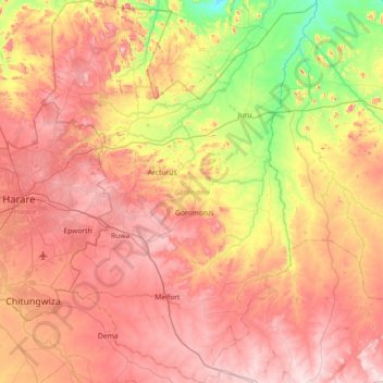
Name: Goromonzi topographic map, elevation, terrain.
Location: Goromonzi, Mashonaland East Province, Zimbabwe (-18.16168 31.08788 -17.47483 31.60868)
Average elevation: 1,396 m
Minimum elevation: 1,077 m
Maximum elevation: 1,692 m
Make a donation
Other topographic maps
Click on a map to view its topography, its elevation and its terrain.
Marondera
Zimbabwe > Mashonaland East Province > Marondera
Marondera is situated on the highveld plateau, and has a subtropical highland climate (Köppen Cwb). The city enjoys a sunny climate, with the summer months (October to April) characterised by warm to hot days followed by afternoon thundershowers and cool evenings, and the winter months (May to September) by…
Average elevation: 1,637 m
Make a donation
Marondera
Zimbabwe > Mashonaland East Province > Marondera
Marondera is situated on the highveld plateau, and has a subtropical highland climate (Köppen Cwb). The city enjoys a sunny climate, with the summer months (October to April) characterised by warm to hot days followed by afternoon thundershowers and cool evenings, and the winter months (May to September) by…
Average elevation: 1,637 m