
Saudi Arabia topographic map
Click on the map to display elevation.
Saudi Arabia
Saudi Arabia's geography is dominated by the Arabian Desert, associated semi-desert and shrubland (see satellite image) and several mountain ranges and highlands. It is, in fact, a number of linked deserts and includes the 647,500 km2 (250,001 sq mi) Rub' al Khali ("Empty Quarter") in the southeastern part of the country, the world's largest contiguous sand desert. Though there are a few lakes in the country, Saudi Arabia is the largest country in the world by area with no permanent rivers. Wadis, however, are very numerous. The fertile areas are to be found in the alluvial deposits in wadis, basins, and oases. The main topographical feature is the central plateau which rises abruptly from the Red Sea and gradually descends into the Nejd and toward the Persian Gulf. On the Red Sea coast, there is a narrow coastal plain, known as the Tihamah parallel to which runs an imposing escarpment. The southwest province of Asir is mountainous, and contains the 3,133 m (10,279 ft) Mount Sawda, which is the highest point in the country.
About this map
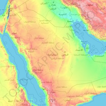
Name: Saudi Arabia topographic map, elevation, terrain.
Location: Saudi Arabia (16.29000 34.45717 32.15428 55.66669)
Average elevation: 551 m
Minimum elevation: -415 m
Maximum elevation: 3,894 m
Other topographic maps
Click on a map to view its topography, its elevation and its terrain.
Hwange
Zimbabwe > Matabeleland North Province > Hwange
Hwange (formerly Wankie) is a town in Zimbabwe, located in Hwange District, in Matabeleland North Province, in northwestern Zimbabwe, close to the international borders with Botswana and Zambia. It lies approximately 100 kilometres (62 mi), by road, southeast of Victoria Falls, the nearest large city. The town…
Average elevation: 774 m
Marondera
Zimbabwe > Mashonaland East Province > Marondera
Marondera is situated on the highveld plateau, and has a subtropical highland climate (Köppen Cwb). The city enjoys a sunny climate, with the summer months (October to April) characterised by warm to hot days followed by afternoon thundershowers and cool evenings, and the winter months (May to September) by…
Average elevation: 1,637 m
Mutare
Zimbabwe > Manicaland Province > Mutare
Despite its tropical location, the city has a humid subtropical climate, of the highland variety moderated by its altitude. Mutare experiences drizzle almost throughout the year. The average annual temperature is 19 °C, surprisingly low for its moderate altitude (about the same as Harare which is 360 metres…
Average elevation: 1,160 m
Victoria Falls
Zimbabwe > Matabeleland North Province > Hwange > Victoria Falls Municipality
Average elevation: 918 m
Chinhoyi
Zimbabwe > Mashonaland West Province > Makonde
The geographical coordinates of Chinhoyi are:17°20'59.0"S, 30°11'40.0"E (Latitude:-17.349722; Longitude:30.194444). Chinhoyi sits at an average elevation of 1,187 metres (3,894 ft) above mean sea level.
Average elevation: 1,167 m
Kariba
Zimbabwe > Mashonaland West Province > Kariba
Kariba has a tropical savanna climate (Köppen climate classification Aw), with warm winters and very hot summers, and a marked drier season in the winter. Although it is relatively cooler than typical tropical places in the winter and does get occasional 5 °C (41 °F) lows, Kariba nevertheless meets the…
Average elevation: 550 m
Beitbridge
Zimbabwe > Matabeleland South Province > Beitbridge > Municipality of Beitbridge
Average elevation: 479 m
Kadoma
Zimbabwe > Mashonaland West Province > Kadoma
The city is located in Kadoma District, Mashonaland West Province, one of the 10 administrative provinces in Zimbabwe. This location lies approximately 141 kilometres (88 mi), by road, southwest of Harare, the national capital and largest city in the country. The city lies on Highway A-5, between Harare and…
Average elevation: 1,134 m
Gwanda
Zimbabwe > Matabeleland South Province > Gwanda
The town is located 134 kilometres (83 mi), by road, south east of the city of Bulawayo, Zimbabwe's second largest city. This location lies on the Bulawayo–Beitbridge Road and the Beitbridge Bulawayo Railway. The town of Beitbridge, at Zimbabwe's border with the Republic of South Africa, lies approximately…
Average elevation: 1,012 m
Kwekwe
Zimbabwe > Midlands Province > Kwekwe
The town is situated on Zimbabwe's Highveld at an altitude of 1,220 metres (4,000 ft), above sea level. It is located in the tropics but its high altitude modifies this to a warm temperate or humid subtropical climate.
Average elevation: 1,200 m
Bulawayo
Zimbabwe > Bulawayo Province > Bulawayo
Due to its relatively high altitude, the city has a humid subtropical climate despite lying in the tropics. Under the Köppen climate classification, Bulawayo features a semiarid climate (BSh). The mean annual temperature is 19.16 °C (66.49 °F), similar to Pretoria at a similar altitude but almost 600 km…
Average elevation: 1,348 m
Harare
Harare (/həˈrɑːreɪ/ hə-RAR-ay), originally known as Salisbury (/ˈsɔːlzbəri/ SAWLZ-bər-ee), is the capital and most populous city of Zimbabwe. The city proper has an area of 940 km2 (371 mi2) a population of 2.12 million in the 2012 census and an estimated 3.12 million in its metropolitan area in…
Average elevation: 1,470 m
Durbanville
South Africa > Western Cape > City of Cape Town
Durbanville is situated in the northern suburbs of Cape Town, approximately 28 kilometres (17.4 mi) north-east of the city, bordered by Bellville to the south, Brackenfell to the south-east and Kraaifontein to the east. It lies at an altitude of between 100 m (328 ft) to 240 m (787 ft), in the vast rolling…
Average elevation: 157 m
Jersey
Jersey is an island measuring 118.2 square kilometres (45.6 sq mi) (or 66,436 vergées), including reclaimed land and intertidal zone. It lies in the English Channel, about 12 nautical miles (22 km; 14 mi) from the Cotentin Peninsula in Normandy, France, and about 87 nautical miles (161 km; 100 mi) south of…
Average elevation: 145 m
Prnjavor
Bosnia and Herzegovina > Republika Srpska > Town of Prnjavor
The municipality is located in the basin of the Ukrina river and is characterized by a mostly lowland hilly terrain configuration with the highest peak of 594m (mountain Ljubić). The Municipality of Prnjavor is shielded on all sides by low mountains such as Ljubić (south) and Motajica (north). The town of…
Average elevation: 180 m
Bukoba
Bukoba has an upland tropical monsoon climate (Köppen Amb, because every month has a normal mean temperature of between 18 °C and 22 °C) although it is milder than most climates with that classification due to its altitude. It can sometimes get cool especially in the evenings during the two rainy seasons,…
Average elevation: 1,177 m
Abha
Abha is located in the southern region of Asir at an elevation of about 2,270 metres (7,450 feet) above sea level. Abha lies on the western edge of Mount Al-Hijaz, near Jabal Sawda, the highest peak in Saudi Arabia. Treating the Asir Mountains as part of the Sarawat, the landscape is otherwise dominated by the…
Average elevation: 1,994 m
Emirates Motorplex - UAQ/RAK road
United Arab Emirates > Umm al-Quwain Emirate > Umm Al Quwain
Average elevation: 5 m
Irving
United States > Pennsylvania > Schuylkill County > Pine Grove Township
Average elevation: 199 m
Recklinghausen (Sauerland)
Germany > North Rhine-Westphalia > Hochsauerlandkreis > Sundern
Average elevation: 332 m
Tuzla
Bosnia and Herzegovina > Federation of Bosnia and Herzegovina > City of Tuzla
Average elevation: 349 m
Bir Tawil
Average elevation: 405 m
Udhagamandalam
India > Tamil Nadu > Udhagamandalam
Ooty is located in the Nilgiri hills, which are part of the Western Ghats in the Nilgiri Biosphere Reserve. It is separated from the neighboring state of Karnataka by the Moyar river in the north and from the Anaimalai and Palani hills in the south by the Palghat Gap. It is situated at an altitude of 2,240…
Average elevation: 2,234 m
San Martino / San Martin
Italy > Friuli – Venezia Giulia > Pordenone / Pordenon > Erto e Casso / Nert e Cjas > Erto / Nert
Average elevation: 1,095 m
Chitral
Pakistan > Khyber Pakhtunkhwa > Chitrāl District
The city has an average elevation of 1,500 m (4,921 ft).
Average elevation: 2,982 m
Monterrey
Mexico > Nuevo León > Monterrey
The city of Monterrey is 540 metres (1,770 ft) above sea level in the northeastern state of Nuevo León. Monterrey translated literally from Spanish to English is "King Mount" or "King Mountain", and folk etymology claims that this refers to the city's topography and the large mountains that surround it…
Average elevation: 753 m
Ramallah
Palestinian Territories > Area A
Ramallah (UK: /rəˈmælə/ rə-MAL-ə, US: /rəˈmɑːlə/ rə-MAH-lə; Arabic: رام الله, romanized: Rām Allāh; IPA: [raːm alˤ.lˤaːh] ; lit. 'God's Height') is a city in the central West Bank, Palestine. It serves as the administrative capital of Palestine, as well as capital of the Ramallah…
Average elevation: 769 m
Africa
Average elevation: 462 m
Thembisa
South Africa > Gauteng > City of Ekurhuleni Metropolitan Municipality
Average elevation: 1,594 m