
Jamaica topographic map
Interactive map
Click on the map to display elevation.
About this map
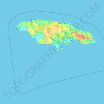
Name: Jamaica topographic map, elevation, terrain.
Location: Jamaica (16.58994 -78.57824 18.72564 -75.75411)
Average elevation: 39 m
Minimum elevation: -2 m
Maximum elevation: 2,198 m
Coral reef ecosystems are important because they provide people with a source of livelihood, food, recreation, and medicinal compounds and protect the land on which they live. Jamaica relies on the ocean and its ecosystem for its development. However, the marine life in Jamaica is also being affected. There could be many factors that contribute to marine life not having the best health. Jamaica's geological origin, topographical features and seasonal high rainfall make it susceptible to a range of natural hazards that can affect the coastal and oceanic environments. These include storm surge, slope failures (landslides), earthquakes, floods and hurricanes. Coral reefs in the Negril Marine Park (NMP), Jamaica, have been increasingly impacted by nutrient pollution and macroalgal blooms following decades of intensive development as a major tourist destination. Another one of those factors could include tourism: being that Jamaica is a very touristy place, the island draws numerous people traveling here from all over the world. The Jamaican tourism industry accounts for 32% of total employment and 36% of the country's GDP and is largely based on the sun, sea and sand, the last two of these attributes being dependent on healthy coral reef ecosystems. Because of Jamaica's tourism, they have developed a study to see if the tourist would be willing to help financially to manage their marine ecosystem because Jamaica alone is unable to. The ocean connects all the countries all over the world, however, everyone and everything is affecting the flow and life in the ocean. Jamaica is a very touristy place specifically because of their beaches. If their oceans are not functioning at their best then the well-being of Jamaica and the people who live there will start to deteriorate. According to the OECD, oceans contribute $1.5 trillion annually in value-added to the overall economy. A developing country on an island will get the majority of their revenue from their ocean.
Other topographic maps
Click on a map to view its topography, its elevation and its terrain.
Baku
Azerbaijan > Absheron > Baku
Baku, Yasamal Raion, Baku City, Absheron, Azerbaijan
Average elevation: 30 m
Centenary
Uganda > Central Region > Kampala
Centenary, Kampala, Central Region, Uganda
Average elevation: 1,175 m
Manggar
Indonesia > East Kalimantan > Balikpapan
Manggar, Balikpapan Timur, Balikpapan, East Kalimantan, Kalimantan, Indonesia
Average elevation: 11 m
Cinchona Park
Philippines > Bukidnon > Lantapan > Balila > Babahagon
Cinchona Park, Aglayan-Alanib-Ticalaan Road, Purok 1, Babahagon, Balila, Lantapan, Bukidnon, Northern Mindanao, Philippines
Average elevation: 1,245 m
Upper Savoy
Upper Savoy, Auvergne-Rhône-Alpes, Metropolitan France, France
Average elevation: 1,032 m
Zimbabwe
Zimbabwe
Average elevation: 869 m
Damariscotta
United States > Maine > Lincoln County
Damariscotta, Lincoln County, Maine, 04543, United States
Average elevation: 29 m
Plainview
Plainview, Mandaluyong, Eastern Manila District, Metro Manila, Philippines
Average elevation: 14 m
Mkuyuni
Tanzania > Mwanza Region > Mwanza
Mkuyuni, Mwanza, Nyamagana, Mwanza Region, Lake Zone, Tanzania
Average elevation: 1,177 m
Huế
Vietnam > Thừa Thiên Huế Province
Huế, Thừa Thiên Huế Province, 54000, Vietnam
Average elevation: 24 m
Bega River
Philippines > Davao de Oro > Laak
Bega River, Laak, Davao de Oro, Davao Region, 8810, Philippines
Average elevation: 148 m
Nobleboro
United States > Maine > Lincoln County
Nobleboro, Lincoln County, Maine, 04555, United States
Average elevation: 40 m
Salem
United States > Arkansas > Fulton County
Salem, Fulton County, Arkansas, United States
Average elevation: 224 m
South Mountain
Canada > Ontario > Stormont, Dundas and Glengarry Counties > North Dundas
South Mountain, North Dundas, Stormont, Dundas and Glengarry Counties, Eastern Ontario, Ontario, K0E 1W0, Canada
Average elevation: 82 m
Hubbard Glacier
United States > Alaska > Yakutat
Hubbard Glacier, Yakutat, Alaska, United States
Average elevation: 1,892 m
Newry
United States > Maine > Oxford County
Newry, Oxford County, Maine, 04261, United States
Average elevation: 392 m
Withersfield
United Kingdom > England > Suffolk > West Suffolk
Withersfield, West Suffolk, Suffolk, England, United Kingdom
Average elevation: 102 m
Évry
France > Bourgogne – Franche-Comté > Yonne
Évry, Sens, Yonne, Bourgogne – Franche-Comté, Metropolitan France, 89140, France
Average elevation: 68 m
Nerva
Spain > Andalusia > Cuenca Minera
Nerva, Cuenca Minera, Huelva, Andalusia, 21670, Spain
Average elevation: 365 m
Belvedere Marittimo
Belvedere Marittimo, Cosenza, Calabria, 87021, Italy
Average elevation: 266 m
Conway
United States > New Hampshire > Carroll County
Conway, Carroll County, New Hampshire, United States
Average elevation: 256 m
Hovingham
United Kingdom > England > North Yorkshire
Hovingham, North Yorkshire, England, YO62 4JU, United Kingdom
Average elevation: 51 m
Nunnington
United Kingdom > England > Herefordshire > Withington Marsh
Nunnington, Withington Marsh, Withington, Herefordshire, England, HR1 3NJ, United Kingdom
Average elevation: 63 m
Münchsmünster
Germany > Bavaria > Landkreis Pfaffenhofen an der Ilm
Münchsmünster, Landkreis Pfaffenhofen an der Ilm, Bavaria, 85126, Germany
Average elevation: 360 m
Mühleberg
Switzerland > Bern > Bern-Mittelland administrative district
Mühleberg, Bern-Mittelland administrative district, Bernese Mittelland administrative region, Bern, Switzerland
Average elevation: 551 m
New Orleans
United States > Louisiana > Orleans Parish
New Orleans, Orleans Parish, Louisiana, United States
Average elevation: 1 m
Bizana
South Africa > Eastern Cape > Alfred Nzo District Municipality > Mbizana Local Municipality
Bizana, Mbizana Local Municipality, Alfred Nzo District Municipality, Eastern Cape, South Africa
Average elevation: 823 m
Llanfyllin
United Kingdom > Wales > Powys
Llanfyllin, Powys, Wales, SY22 5AU, United Kingdom
Average elevation: 208 m
Serra de Santo António
Portugal > Santarém > Alcanena
Serra de Santo António, Alcanena, Santarém, Portugal
Average elevation: 338 m
Shurdington
United Kingdom > England > Gloucestershire > Tewkesbury
Shurdington, Tewkesbury, Gloucestershire, England, GL51 4TQ, United Kingdom
Average elevation: 87 m
Site of Community Importance Serra da Estrela
Site of Community Importance Serra da Estrela, Guarda, Portugal
Average elevation: 742 m
Ninfield
United Kingdom > England > East Sussex > Wealden > Ninfield
Ninfield, Wealden, East Sussex, England, United Kingdom
Average elevation: 37 m
Amargadhi-06
Nepal > Sudurpashchim Province > Dadeldhura > Pokhara
Amargadhi-06, Pokhara, Amargadhi, Dadeldhura, Sudurpashchim Province, Nepal
Average elevation: 1,626 m
West St. Paul
United States > Minnesota > Dakota County
West St. Paul, Dakota County, Minnesota, 55118, United States
Average elevation: 294 m
Wollaton
United Kingdom > England > Nottingham
Wollaton, Nottingham, England, NG8 2AF, United Kingdom
Average elevation: 58 m
Bramcote
United Kingdom > England > Warwickshire > Rugby
Bramcote, Rugby, Warwickshire, England, CV11 6QX, United Kingdom
Average elevation: 105 m
Menifee County
Menifee County, Kentucky, United States
Average elevation: 313 m
Kurgan
Russia > Kurgan Oblast > Kurgan
Kurgan, Kurgan Oblast, Ural Federal District, Russia
Average elevation: 96 m
Battle
United Kingdom > England > East Sussex > Rother > Battle
Battle, Rother, East Sussex, England, United Kingdom
Average elevation: 66 m
Hastings
United Kingdom > England > East Sussex
Hastings, East Sussex, England, United Kingdom
Average elevation: 36 m
Hawkhurst
United Kingdom > England > Kent > Tunbridge Wells
Hawkhurst, Tunbridge Wells, Kent, England, United Kingdom
Average elevation: 67 m
Zamboanga del Norte
Zamboanga del Norte, Zamboanga Peninsula, Philippines
Average elevation: 78 m
Searsmont
United States > Maine > Waldo County
Searsmont, Waldo County, Maine, United States
Average elevation: 98 m