
Zamboanga del Norte topographic map
Interactive map
Click on the map to display elevation.
Zamboanga del Norte
It has an average elevation of 243.8 metres (800 ft), with Mount Dabiak in Katipunan as the highest peak at 2,600 metres (8,500 ft). Other parts, near the coastlines, are plains. The province's irregular coastline runs some 400 kilometres (250 mi) from north to south.
About this map
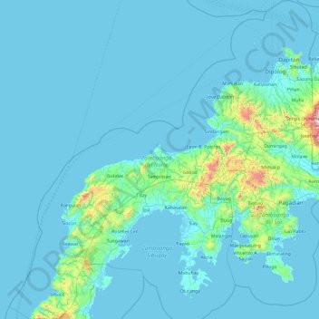
Name: Zamboanga del Norte topographic map, elevation, terrain.
Location: Zamboanga del Norte, Zamboanga Peninsula, Philippines (7.14683 121.78584 8.99718 123.58703)
Average elevation: 78 m
Minimum elevation: -2 m
Maximum elevation: 1,651 m
Other topographic maps
Click on a map to view its topography, its elevation and its terrain.
Bacolod
Philippines > Negros Occidental > Bacolod
Bacólod (English: Bacolod), is derived from bakólod (Old Spelling: bacólod), the Old Hiligaynon (Old Ilonggo) (Old Spelling: Ylongo and Ilongo) word for a "hill, mound, rise, hillock, down, any small eminence or elevation", since the resettlement was founded on a stony, hilly area, now the barangay of…
Average elevation: 49 m
Basilan
Basilan National Park is at the eastern portion of the remaining public forest between the city of Isabela and the municipalities of Lamitan, Tipo-Tipo and Sumisip. The park has an elevation of 971 metres (3,186 ft) above sea level, and the tallest peak, Puno Mahaji or Basilan Peak, dominates the park's…
Average elevation: 42 m