
Mühleberg topographic map
Interactive map
Click on the map to display elevation.
About this map
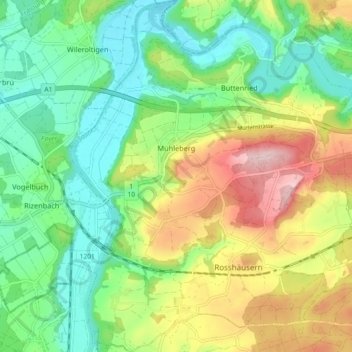
Name: Mühleberg topographic map, elevation, terrain.
Average elevation: 551 m
Minimum elevation: 458 m
Maximum elevation: 713 m
Other topographic maps
Click on a map to view its topography, its elevation and its terrain.
Bern
Switzerland > Bern > Bern-Mittelland administrative district > Bern
Bern, Bern-Mittelland administrative district, Bernese Mittelland administrative region, Bern, 3011, Switzerland
Average elevation: 643 m