
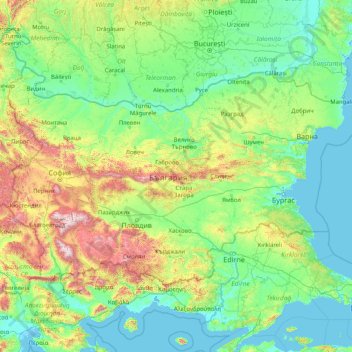
Bulgaria topographic map
Interactive map
Click on the map to display elevation.
About this map
Name: Bulgaria topographic map, elevation, terrain.
Location: Bulgaria (41.23537 22.35715 44.21554 28.88754)
Average elevation: 300 m
Minimum elevation: -3 m
Maximum elevation: 2,750 m
Bulgaria occupies a portion of the eastern Balkan peninsula, bordering five countries—Greece and Turkey to the south, Macedonia and Serbia to the west, and Romania to the north. The land borders have a total length of 1,808 kilometres (1,123 mi), and the coastline has a length of 354 kilometres (220 mi). Its total area of 110,994 square kilometres (42,855 sq mi) ranks it as the world's 105th-largest country. Bulgaria's geographic coordinates are 43° N 25° E. The most notable topographical features are the Danubian Plain, the Balkan Mountains, the Thracian Plain, and the Rila-Rhodope massif. The southern edge of the Danubian Plain slopes upward into the foothills of the Balkans, while the Danube defines the border with Romania. The Thracian Plain is roughly triangular, beginning southeast of Sofia and broadening as it reaches the Black Sea coast.
Other topographic maps
Click on a map to view its topography, its elevation and its terrain.
Baku
Azerbaijan > Absheron > Baku
Baku, Yasamal Raion, Baku City, Absheron, Azerbaijan
Average elevation: 30 m
Centenary
Uganda > Central Region > Kampala
Centenary, Kampala, Central Region, Uganda
Average elevation: 1,175 m
Manggar
Indonesia > East Kalimantan > Balikpapan
Manggar, Balikpapan Timur, Balikpapan, East Kalimantan, Kalimantan, Indonesia
Average elevation: 11 m
Cinchona Park
Philippines > Bukidnon > Lantapan > Balila > Babahagon
Cinchona Park, Aglayan-Alanib-Ticalaan Road, Purok 1, Babahagon, Balila, Lantapan, Bukidnon, Northern Mindanao, Philippines
Average elevation: 1,245 m
Upper Savoy
Upper Savoy, Auvergne-Rhône-Alpes, Metropolitan France, France
Average elevation: 1,032 m
Zimbabwe
Zimbabwe
Average elevation: 869 m
Damariscotta
United States > Maine > Lincoln County
Damariscotta, Lincoln County, Maine, 04543, United States
Average elevation: 29 m
Plainview
Plainview, Mandaluyong, Eastern Manila District, Metro Manila, Philippines
Average elevation: 14 m
Mkuyuni
Tanzania > Mwanza Region > Mwanza
Mkuyuni, Mwanza, Nyamagana, Mwanza Region, Lake Zone, Tanzania
Average elevation: 1,177 m
Huế
Vietnam > Thừa Thiên Huế Province
Huế, Thừa Thiên Huế Province, 54000, Vietnam
Average elevation: 24 m
Bega River
Philippines > Davao de Oro > Laak
Bega River, Laak, Davao de Oro, Davao Region, 8810, Philippines
Average elevation: 148 m
Nobleboro
United States > Maine > Lincoln County
Nobleboro, Lincoln County, Maine, 04555, United States
Average elevation: 40 m
Salem
United States > Arkansas > Fulton County
Salem, Fulton County, Arkansas, United States
Average elevation: 224 m
South Mountain
Canada > Ontario > Stormont, Dundas and Glengarry Counties > North Dundas
South Mountain, North Dundas, Stormont, Dundas and Glengarry Counties, Eastern Ontario, Ontario, K0E 1W0, Canada
Average elevation: 82 m
Hubbard Glacier
United States > Alaska > Yakutat
Hubbard Glacier, Yakutat, Alaska, United States
Average elevation: 1,892 m
Newry
United States > Maine > Oxford County
Newry, Oxford County, Maine, 04261, United States
Average elevation: 392 m
Withersfield
United Kingdom > England > Suffolk > West Suffolk
Withersfield, West Suffolk, Suffolk, England, United Kingdom
Average elevation: 102 m
Évry
France > Bourgogne – Franche-Comté > Yonne
Évry, Sens, Yonne, Bourgogne – Franche-Comté, Metropolitan France, 89140, France
Average elevation: 68 m
Nerva
Spain > Andalusia > Cuenca Minera
Nerva, Cuenca Minera, Huelva, Andalusia, 21670, Spain
Average elevation: 365 m
Belvedere Marittimo
Belvedere Marittimo, Cosenza, Calabria, 87021, Italy
Average elevation: 266 m
Conway
United States > New Hampshire > Carroll County
Conway, Carroll County, New Hampshire, United States
Average elevation: 256 m
Hovingham
United Kingdom > England > North Yorkshire
Hovingham, North Yorkshire, England, YO62 4JU, United Kingdom
Average elevation: 51 m
Nunnington
United Kingdom > England > Herefordshire > Withington Marsh
Nunnington, Withington Marsh, Withington, Herefordshire, England, HR1 3NJ, United Kingdom
Average elevation: 63 m
Münchsmünster
Germany > Bavaria > Landkreis Pfaffenhofen an der Ilm
Münchsmünster, Landkreis Pfaffenhofen an der Ilm, Bavaria, 85126, Germany
Average elevation: 360 m
Mühleberg
Switzerland > Bern > Bern-Mittelland administrative district
Mühleberg, Bern-Mittelland administrative district, Bernese Mittelland administrative region, Bern, Switzerland
Average elevation: 551 m
New Orleans
United States > Louisiana > Orleans Parish
New Orleans, Orleans Parish, Louisiana, United States
Average elevation: 1 m
Bizana
South Africa > Eastern Cape > Alfred Nzo District Municipality > Mbizana Local Municipality
Bizana, Mbizana Local Municipality, Alfred Nzo District Municipality, Eastern Cape, South Africa
Average elevation: 823 m
Llanfyllin
United Kingdom > Wales > Powys
Llanfyllin, Powys, Wales, SY22 5AU, United Kingdom
Average elevation: 208 m
Serra de Santo António
Portugal > Santarém > Alcanena
Serra de Santo António, Alcanena, Santarém, Portugal
Average elevation: 338 m
Shurdington
United Kingdom > England > Gloucestershire > Tewkesbury
Shurdington, Tewkesbury, Gloucestershire, England, GL51 4TQ, United Kingdom
Average elevation: 87 m
Site of Community Importance Serra da Estrela
Site of Community Importance Serra da Estrela, Guarda, Portugal
Average elevation: 742 m
Ninfield
United Kingdom > England > East Sussex > Wealden > Ninfield
Ninfield, Wealden, East Sussex, England, United Kingdom
Average elevation: 37 m
Amargadhi-06
Nepal > Sudurpashchim Province > Dadeldhura > Pokhara
Amargadhi-06, Pokhara, Amargadhi, Dadeldhura, Sudurpashchim Province, Nepal
Average elevation: 1,626 m
West St. Paul
United States > Minnesota > Dakota County
West St. Paul, Dakota County, Minnesota, 55118, United States
Average elevation: 294 m
Wollaton
United Kingdom > England > Nottingham
Wollaton, Nottingham, England, NG8 2AF, United Kingdom
Average elevation: 58 m
Bramcote
United Kingdom > England > Warwickshire > Rugby
Bramcote, Rugby, Warwickshire, England, CV11 6QX, United Kingdom
Average elevation: 105 m
Menifee County
Menifee County, Kentucky, United States
Average elevation: 313 m
Kurgan
Russia > Kurgan Oblast > Kurgan
Kurgan, Kurgan Oblast, Ural Federal District, Russia
Average elevation: 96 m
Battle
United Kingdom > England > East Sussex > Rother > Battle
Battle, Rother, East Sussex, England, United Kingdom
Average elevation: 66 m
Hastings
United Kingdom > England > East Sussex
Hastings, East Sussex, England, United Kingdom
Average elevation: 36 m
Hawkhurst
United Kingdom > England > Kent > Tunbridge Wells
Hawkhurst, Tunbridge Wells, Kent, England, United Kingdom
Average elevation: 67 m
Zamboanga del Norte
Zamboanga del Norte, Zamboanga Peninsula, Philippines
Average elevation: 78 m
Searsmont
United States > Maine > Waldo County
Searsmont, Waldo County, Maine, United States
Average elevation: 98 m