
Italië topographic map
Interactive map
Click on the map to display elevation.
About this map
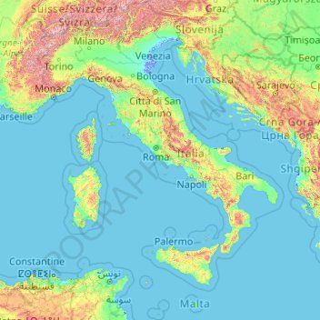
Name: Italië topographic map, elevation, terrain.
Location: Italië (35.28896 6.62727 47.09215 18.78447)
Average elevation: 293 m
Minimum elevation: -6 m
Maximum elevation: 4,188 m
In 1935 werd het Keizerrijk Ethiopië binnengevallen door Mussolini, passend in zijn droom van een nieuw Romeinse Rijk. Italië gebruikte gifgas om zo snel mogelijk een overwinning te behalen en kon de Ethiopiërs, die nauwelijks over moderne wapens beschikten, ten slotte verslaan. Het bezette de grote steden in het land, maar door het uitbreken van de Tweede Wereldoorlog zou het niet tot een echte kolonisatie komen. Tijdens de Spaanse Burgeroorlog steunden nazi-Duitsland en Mussolini de troepen van Franco. De annexatie van Ethiopië bij de Italiaanse kolonies in de Hoorn van Afrika (Italiaans-Eritrea en Italiaans Somaliland) werd in 1935 door Franco erkend. Daarmee kwam de samenwerking tussen beide dictaturen tot een hoogtepunt. In 1941 werd het Italiaanse leger na een bezetting van amper vijf jaar weer uit Ethiopië verdreven door Ethiopische verzetsstrijders, het Britse en een Belgisch-Congolees leger.
Other topographic maps
Click on a map to view its topography, its elevation and its terrain.
Mbalabala
Zimbabwe > Matabeleland South Province > Umzingwane
Mbalabala, Umzingwane, Matabeleland South Province, Zimbabwe
Average elevation: 1,100 m
Zimbabwe
Zimbabwe
Average elevation: 869 m
Mount Cole
Mount Cole, Rural City of Ararat, Victoria, 3377, Australia
Average elevation: 538 m
Baku
Azerbaijan > Absheron > Baku
Baku, Yasamal Raion, Baku City, Absheron, Azerbaijan
Average elevation: 30 m
Lake Waconia
United States > Minnesota > Carver County > Waconia
Lake Waconia, Waconia, Waconia Township, Carver County, Minnesota, United States
Average elevation: 294 m
Carisbrooke
United Kingdom > England > Isle of Wight
Carisbrooke, Isle of Wight, England, PO30 1NS, United Kingdom
Average elevation: 42 m
Buenos Aires
Argentina > Autonomous City of Buenos Aires
Buenos Aires, Comuna 1, Autonomous City of Buenos Aires, Argentina
Average elevation: 9 m
Bolivia
Bolivia
Average elevation: 1,136 m
Johannesburg
South Africa > Gauteng > City of Johannesburg Metropolitan Municipality
Johannesburg, City of Johannesburg Metropolitan Municipality, Gauteng, 2001, South Africa
Average elevation: 1,615 m
Bristol
United States > Maine > Lincoln County
Bristol, Lincoln County, Maine, United States
Average elevation: 13 m
Bristol
United Kingdom > England > City of Bristol
Bristol, City of Bristol, West of England, England, United Kingdom
Average elevation: 55 m
Plainview
Plainview, Mandaluyong, Eastern Manila District, Metro Manila, Philippines
Average elevation: 14 m
Centenary
Uganda > Central Region > Kampala
Centenary, Kampala, Central Region, Uganda
Average elevation: 1,175 m
Manggar
Indonesia > East Kalimantan > Balikpapan
Manggar, Balikpapan Timur, Balikpapan, East Kalimantan, Kalimantan, Indonesia
Average elevation: 11 m
Cinchona Park
Philippines > Bukidnon > Lantapan > Balila > Babahagon
Cinchona Park, Aglayan-Alanib-Ticalaan Road, Purok 1, Babahagon, Balila, Lantapan, Bukidnon, Northern Mindanao, Philippines
Average elevation: 1,245 m
Upper Savoy
Upper Savoy, Auvergne-Rhône-Alpes, Metropolitan France, France
Average elevation: 1,032 m
Mkuyuni
Tanzania > Mwanza Region > Mwanza
Mkuyuni, Mwanza, Nyamagana, Mwanza Region, Lake Zone, Tanzania
Average elevation: 1,177 m
Damariscotta
United States > Maine > Lincoln County
Damariscotta, Lincoln County, Maine, 04543, United States
Average elevation: 29 m
Huế
Vietnam > Thừa Thiên Huế Province
Huế, Thừa Thiên Huế Province, 54000, Vietnam
Average elevation: 24 m
Bega River
Philippines > Davao de Oro > Laak
Bega River, Laak, Davao de Oro, Davao Region, 8810, Philippines
Average elevation: 148 m
Nobleboro
United States > Maine > Lincoln County
Nobleboro, Lincoln County, Maine, 04555, United States
Average elevation: 40 m
Salem
United States > Arkansas > Fulton County
Salem, Fulton County, Arkansas, United States
Average elevation: 224 m
South Mountain
Canada > Ontario > Stormont, Dundas and Glengarry Counties > North Dundas
South Mountain, North Dundas, Stormont, Dundas and Glengarry Counties, Eastern Ontario, Ontario, K0E 1W0, Canada
Average elevation: 82 m
Hubbard Glacier
United States > Alaska > Yakutat
Hubbard Glacier, Yakutat, Alaska, United States
Average elevation: 1,892 m
Newry
United States > Maine > Oxford County
Newry, Oxford County, Maine, 04261, United States
Average elevation: 392 m
Withersfield
United Kingdom > England > Suffolk > West Suffolk
Withersfield, West Suffolk, Suffolk, England, United Kingdom
Average elevation: 102 m
Évry
France > Bourgogne – Franche-Comté > Yonne
Évry, Sens, Yonne, Bourgogne – Franche-Comté, Metropolitan France, 89140, France
Average elevation: 68 m
Belvedere Marittimo
Belvedere Marittimo, Cosenza, Calabria, 87021, Italy
Average elevation: 266 m
Nerva
Spain > Andalusia > Cuenca Minera
Nerva, Cuenca Minera, Huelva, Andalusia, 21670, Spain
Average elevation: 365 m
Conway
United States > New Hampshire > Carroll County
Conway, Carroll County, New Hampshire, United States
Average elevation: 256 m
Serra de Santo António
Portugal > Santarém > Alcanena
Serra de Santo António, Alcanena, Santarém, Portugal
Average elevation: 338 m
Hovingham
United Kingdom > England > North Yorkshire
Hovingham, North Yorkshire, England, YO62 4JU, United Kingdom
Average elevation: 51 m
Nunnington
United Kingdom > England > Herefordshire > Withington Marsh
Nunnington, Withington Marsh, Withington, Herefordshire, England, HR1 3NJ, United Kingdom
Average elevation: 63 m
Münchsmünster
Germany > Bavaria > Landkreis Pfaffenhofen an der Ilm
Münchsmünster, Landkreis Pfaffenhofen an der Ilm, Bavaria, 85126, Germany
Average elevation: 360 m
Mühleberg
Switzerland > Bern > Bern-Mittelland administrative district
Mühleberg, Bern-Mittelland administrative district, Bernese Mittelland administrative region, Bern, Switzerland
Average elevation: 551 m
New Orleans
United States > Louisiana > Orleans Parish
New Orleans, Orleans Parish, Louisiana, United States
Average elevation: 1 m
Bizana
South Africa > Eastern Cape > Alfred Nzo District Municipality > Mbizana Local Municipality
Bizana, Mbizana Local Municipality, Alfred Nzo District Municipality, Eastern Cape, South Africa
Average elevation: 823 m
Llanfyllin
United Kingdom > Wales > Powys
Llanfyllin, Powys, Wales, SY22 5AU, United Kingdom
Average elevation: 208 m
Shurdington
United Kingdom > England > Gloucestershire > Tewkesbury
Shurdington, Tewkesbury, Gloucestershire, England, GL51 4TQ, United Kingdom
Average elevation: 87 m
Site of Community Importance Serra da Estrela
Site of Community Importance Serra da Estrela, Guarda, Portugal
Average elevation: 742 m
Ninfield
United Kingdom > England > East Sussex > Wealden > Ninfield
Ninfield, Wealden, East Sussex, England, United Kingdom
Average elevation: 37 m