Geolocate

Ramsbottom topographic map

Interactive map

Click on the map to display elevation.

About this map

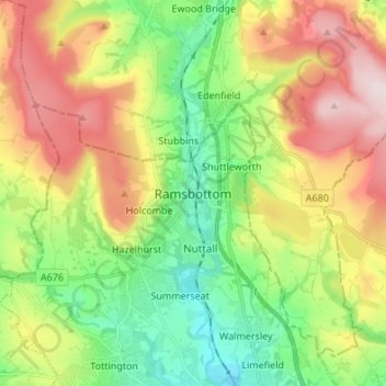
Name: Ramsbottom topographic map, elevation, terrain.

Location: Ramsbottom, Bury, Greater Manchester, England, BL0 9BP, United Kingdom (53.60838 -2.35570 53.68838 -2.27570)

Average elevation: 248 m

Minimum elevation: 88 m

Maximum elevation: 477 m

Other topographic maps

Click on a map to view its topography, its elevation and its terrain.

Portsea Island

United Kingdom > England > Portsmouth

Average elevation: 3 m

Hainford

United Kingdom > England > Norfolk > Broadland

Average elevation: 21 m

Altarnun

United Kingdom > England > Cornwall

Average elevation: 260 m

Sutton Valence

United Kingdom > England > Kent > Maidstone

Average elevation: 55 m

Selston CP

United Kingdom > England > Nottinghamshire > Ashfield

Average elevation: 118 m

Brampford Speke

United Kingdom > England > Devon > East Devon

Average elevation: 40 m

Christow

United Kingdom > England > Devon > Teignbridge

Average elevation: 200 m

Fifield

United Kingdom > England > Oxfordshire > West Oxfordshire

Average elevation: 151 m

Amcotts

United Kingdom > England > North Lincolnshire

Average elevation: 12 m

Longridge

United Kingdom > England > Lancashire > Ribble Valley

Average elevation: 89 m

Staplehurst

United Kingdom > England > Kent > Maidstone

Average elevation: 26 m

Enderby

United Kingdom > England > Leicestershire > Blaby

Average elevation: 78 m

Syston

United Kingdom > England > Leicestershire > Charnwood

Average elevation: 57 m

Clavering

United Kingdom > England > Uttlesford

Average elevation: 108 m

Hayle

United Kingdom > England > Cornwall

Average elevation: 30 m

St. Columb Major

United Kingdom > England > Cornwall

St Columb occupies a plateau at about 300 feet (91 m) elevation. The north part of the town (known as 'Bridge') descends into the Vale of Lanherne, having a minimum elevation of approximately 165 feet (50 m). It was originally a linear settlement built on the main road running north-east to south-west, but…

Average elevation: 110 m

Mansfield

United Kingdom > England > Nottinghamshire

Average elevation: 117 m

Shropshire (Ceremonial)

United Kingdom > England

The climate of Shropshire is moderate. Rainfall averages 760 to 1,000 mm (30 to 40 in), influenced by being in the rainshadow of the Cambrian Mountains from warm, moist frontal systems of the Atlantic Ocean which bring generally light precipitation in Autumn and Spring. The hilly areas in the south and west…

Average elevation: 143 m

Holtby

United Kingdom > England > York

Average elevation: 21 m

Nun Monkton

United Kingdom > England > North Yorkshire

Average elevation: 14 m

Okehampton

United Kingdom > England > Devon

Average elevation: 206 m

Bristol

United Kingdom > England > City of Bristol

Average elevation: 55 m

Withersfield

United Kingdom > England > Suffolk > West Suffolk

Average elevation: 102 m

Ninfield

United Kingdom > England > East Sussex > Wealden > Ninfield

Average elevation: 37 m

Hawkhurst

United Kingdom > England > Kent > Tunbridge Wells

Average elevation: 67 m

Battle

United Kingdom > England > East Sussex > Rother > Battle

Average elevation: 66 m

Great Notley

United Kingdom > England > Braintree

Average elevation: 71 m

Swannington

United Kingdom > England > Norfolk > Broadland

Average elevation: 29 m

Hastings

United Kingdom > England > East Sussex

Average elevation: 36 m

Crofton

United Kingdom > England > Wakefield > Crofton

Average elevation: 54 m

Great Barton

United Kingdom > England > Suffolk > West Suffolk

Average elevation: 54 m

Norwich

United Kingdom > England > Norfolk

Average elevation: 28 m

Ely

United Kingdom > England > Cambridgeshire

Ely is built on a 23-square-mile (60 km2) Kimmeridge Clay island which, at 85 feet (26 m), is the highest land in the Fens. It was due to this topography that Ely was not waterlogged like the surrounding Fenland, and was an island separated from the mainland. Major rivers including the Witham, Welland, Nene…

Average elevation: 4 m

Hundon

United Kingdom > England > Suffolk > West Suffolk

Average elevation: 96 m

Edmondsley

United Kingdom > England > County Durham

Average elevation: 112 m

Newmarket

United Kingdom > England > Suffolk > West Suffolk

Average elevation: 45 m

Winterborne Kingston

United Kingdom > England > Dorset

Average elevation: 77 m

Gateshead

United Kingdom > England > Tyne and Wear

Average elevation: 81 m

Thorpe-le-Soken

United Kingdom > England > Tendring

Average elevation: 15 m

East Riding of Yorkshire

United Kingdom > England

The western part of the district in the Vale of York borders on and is drained by the River Derwent. The landscape is generally low-lying and flat although minor ridges and glacial moraines provide some variations in topography. Where there are dry sandy soils there are remnants of historic heathlands and…

Average elevation: 30 m

Kilham

United Kingdom > England > Northumberland

Average elevation: 187 m

Ringwood

United Kingdom > England > Hampshire > New Forest > Ringwood

Average elevation: 34 m

Kenilworth

United Kingdom > England > Warwickshire

Average elevation: 88 m

Southend-on-Sea

United Kingdom > England

Average elevation: 12 m

Read

United Kingdom > England > Lancashire > Ribble Valley

Average elevation: 114 m

Greater London

United Kingdom > England

Average elevation: 66 m

Northampton

United Kingdom > England > Northampton > Northampton

As with the rest of the British Isles, Northampton experiences a maritime climate with cool summers and mild winters. The official Met Office weather station for Northampton is the Moulton Park Weather Station at the University of Northampton. Situated at an elevation of around 130 m (427 ft) above sea level…

Average elevation: 89 m

Harrogate

United Kingdom > England > Harrogate

Average elevation: 131 m

Uttlesford

United Kingdom > England > Uttlesford

Average elevation: 85 m

Barnsley

United Kingdom > England > Barnsley

Average elevation: 139 m

South East

United Kingdom > England

Average elevation: 69 m

Sheet

United Kingdom > England > East Hampshire

Average elevation: 70 m

Blackpool

United Kingdom > England

Average elevation: 7 m

The Battlefields

United Kingdom > England > Croft

Average elevation: 27 m