
Thank you for supporting this site ❤️
Make a donation
Make a donation
Hayle topographic map
Click on the map to display elevation.
Thank you for supporting this site ❤️
Make a donation
Make a donation
About this map
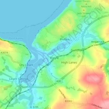
Name: Hayle topographic map, elevation, terrain.
Location: Hayle, Cornwall, England, United Kingdom (50.16480 -5.43722 50.21221 -5.37708)
Average elevation: 30 m
Minimum elevation: -3 m
Maximum elevation: 103 m
Thank you for supporting this site ❤️
Make a donation
Make a donation
Other topographic maps
Click on a map to view its topography, its elevation and its terrain.