
Make a donation
Cebu topographic map
Click on the map to display elevation.
Make a donation
About this map
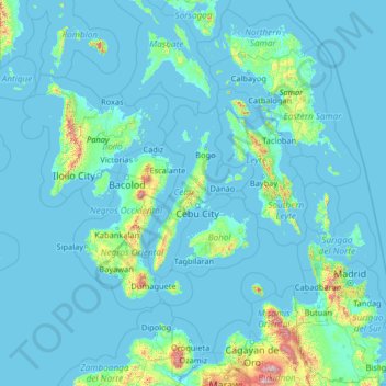
Name: Cebu topographic map, elevation, terrain.
Location: Cebu, Central Visayas, Philippines (7.85000 121.24000 13.05000 126.44000)
Average elevation: 89 m
Minimum elevation: -2 m
Maximum elevation: 2,797 m
Make a donation
Other topographic maps
Click on a map to view its topography, its elevation and its terrain.
Make a donation
Tarlac
Like the rest of Central Luzon, the province has three distinct seasons: summer from March to June, monsoon rain from July to early October, and monsoon winter from late October to February. Summer months, especially during May bring severe thunderstorms with high winds, lightnings, and hails. It is the…
Average elevation: 217 m
Make a donation
Zamboanga del Norte
It has an average elevation of 243.8 metres (800 ft), with Mount Dabiak in Katipunan as the highest peak at 2,600 metres (8,500 ft). Other parts, near the coastlines, are plains. The province's irregular coastline runs some 400 kilometres (250 mi) from north to south.
Average elevation: 78 m
Taal Lake
Taal Lake was once an inlet of nearby Balayan Bay, and was easily navigable from it. A series of major eruptions in the early 18th century battered the lakeside towns with earthquakes and volcanic debris.[7] The activity culminated in 1754 with Taal Volcano's largest eruption that blocked Pansipit River with…
Average elevation: 104 m
Vigan
Vigan is situated in a Quaternary Age sedimentary plain called the Vigan-Bantay Plain which is part of the Ilocos coastal plain. The Vigan-Bantay Plain is bounded on the east by a moderately rugged Miocene sediments consisting of interbedded sandstones and shale to very rugged Meta-volcanics and Meta sediment…
Average elevation: 34 m
Make a donation
Make a donation
Caloocan
South Caloocan, where most commercial and industrial establishments are found, lies on generally flat and highly accessible land, with slopes ranging from 0-3%. The topography gradually changes into gently to moderately sloping to rolling along the North Luzon Expressway, with slopes ranging from 3-18%. The…
Average elevation: 18 m
Make a donation