
Make a donation
Tarlac topographic map
Click on the map to display elevation.
Make a donation
Tarlac
Like the rest of Central Luzon, the province has three distinct seasons: summer from March to June, monsoon rain from July to early October, and monsoon winter from late October to February. Summer months, especially during May bring severe thunderstorms with high winds, lightnings, and hails. It is the coldest province in the region, with a yearly average of 23 °C (73 °F). Cold spell is not common, which gradually receives unusual average temperature of 17 °C (63 °F), while the maximum daytime peaks at 27 °C (81 °F). It is also the windiest province in the region during February and March due to its widely lowland altitude and extreme climate transition. The lowest temperature ever recorded is 11.2 °C (52.2 °F) and the highest temperature is at 38.8 °C (101.8 °F). Aside air temperature, heat index is the most common calculated temperature during extreme weather observances especially dry season. The province usually experiences a maximum heat index ranging from 40 °C (104 °F) to 50 °C (122 °F) based on the forecasts reported by Philippine Atmospheric Geophysical and Astronomical Services Administration.
Make a donation
About this map
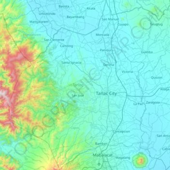
Name: Tarlac topographic map, elevation, terrain.
Location: Tarlac, Central Luzon, Philippines (15.16174 120.16247 15.87898 120.76478)
Average elevation: 217 m
Minimum elevation: 2 m
Maximum elevation: 1,937 m
Make a donation
Other topographic maps
Click on a map to view its topography, its elevation and its terrain.
Make a donation
Make a donation
Make a donation
Make a donation