
Caloocan topographic map
Interactive map
Click on the map to display elevation.
Caloocan
South Caloocan, where most commercial and industrial establishments are found, lies on generally flat and highly accessible land, with slopes ranging from 0-3%. The topography gradually changes into gently to moderately sloping to rolling along the North Luzon Expressway, with slopes ranging from 3-18%. The highest point at 35.00 meters (114.83 ft) above sea level can be found in this area, while the lowest point is in the southern part of Dagat-Dagatan at about 0.993 meters (3 ft 3.1 in) above mean sea level.
About this map
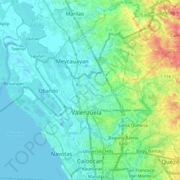
Name: Caloocan topographic map, elevation, terrain.
Average elevation: 18 m
Minimum elevation: -4 m
Maximum elevation: 85 m
Other topographic maps
Click on a map to view its topography, its elevation and its terrain.
Bacolod
Philippines > Negros Occidental > Bacolod
Bacólod (English: Bacolod), is derived from bakólod (Old Spelling: bacólod), the Old Hiligaynon (Old Ilonggo) (Old Spelling: Ylongo and Ilongo) word for a "hill, mound, rise, hillock, down, any small eminence or elevation", since the resettlement was founded on a stony, hilly area, now the barangay of…
Average elevation: 49 m
Basilan
Basilan National Park is at the eastern portion of the remaining public forest between the city of Isabela and the municipalities of Lamitan, Tipo-Tipo and Sumisip. The park has an elevation of 971 metres (3,186 ft) above sea level, and the tallest peak, Puno Mahaji or Basilan Peak, dominates the park's…
Average elevation: 42 m