
Thank you for supporting this site ❤️
Make a donation
Make a donation
Pasig topographic map
Click on the map to display elevation.
Thank you for supporting this site ❤️
Make a donation
Make a donation
About this map
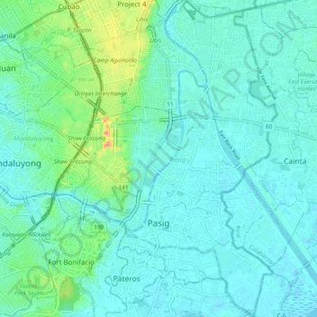
Name: Pasig topographic map, elevation, terrain.
Location: Pasig, Metro Manila, 1600, Philippines (14.53388 121.05158 14.62334 121.11103)
Average elevation: 17 m
Minimum elevation: -2 m
Maximum elevation: 100 m
Thank you for supporting this site ❤️
Make a donation
Make a donation
Other topographic maps
Click on a map to view its topography, its elevation and its terrain.
Thank you for supporting this site ❤️
Make a donation
Make a donation
Thank you for supporting this site ❤️
Make a donation
Make a donation
Thank you for supporting this site ❤️
Make a donation
Make a donation
Thank you for supporting this site ❤️
Make a donation
Make a donation