
Cebu City topographic map
Interactive map
Click on the map to display elevation.
About this map
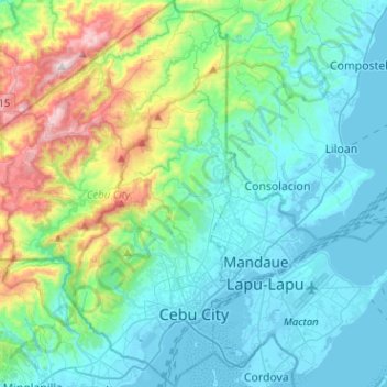
Name: Cebu City topographic map, elevation, terrain.
Location: Cebu City, Central Visayas, Philippines (10.24630 123.75337 10.49575 123.93022)
Average elevation: 197 m
Minimum elevation: -3 m
Maximum elevation: 971 m
Other topographic maps
Click on a map to view its topography, its elevation and its terrain.
Bacolod
Philippines > Negros Occidental > Bacolod
Bacólod (English: Bacolod), is derived from bakólod (Old Spelling: bacólod), the Old Hiligaynon (Old Ilonggo) (Old Spelling: Ylongo and Ilongo) word for a "hill, mound, rise, hillock, down, any small eminence or elevation", since the resettlement was founded on a stony, hilly area, now the barangay of…
Average elevation: 49 m
Basilan
Basilan National Park is at the eastern portion of the remaining public forest between the city of Isabela and the municipalities of Lamitan, Tipo-Tipo and Sumisip. The park has an elevation of 971 metres (3,186 ft) above sea level, and the tallest peak, Puno Mahaji or Basilan Peak, dominates the park's…
Average elevation: 42 m