
Cyprus topographic map
Interactive map
Click on the map to display elevation.
Cyprus
The physical relief of the island is dominated by two mountain ranges, the Troodos Mountains and the smaller Kyrenia Range, and the central plain they encompass, the Mesaoria. The Mesaoria plain is drained by the Pedieos River, the longest on the island. The Troodos Mountains cover most of the southern and western portions of the island and account for roughly half its area. The highest point on Cyprus is Mount Olympus at 1,952 m (6,404 ft), in the centre of the Troodos range. The narrow Kyrenia Range, extending along the northern coastline, occupies substantially less area, and elevations are lower, reaching a maximum of 1,024 m (3,360 ft). The island lies within the Anatolian Plate.
About this map
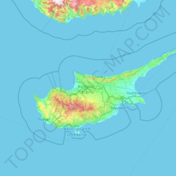
Name: Cyprus topographic map, elevation, terrain.
Location: Cyprus (34.43837 32.02276 35.91325 34.85532)
Average elevation: 73 m
Minimum elevation: -5 m
Maximum elevation: 2,247 m
Other topographic maps
Click on a map to view its topography, its elevation and its terrain.
Gibson Desert
The Gibson Desert is located between the saline Kumpupintil Lake and Lake Macdonald along the Tropic of Capricorn, south of the Great Sandy Desert, east of the Little Sandy Desert, and north of the Great Victoria Desert. The altitude rises to just above 500 metres (1,600 ft) in places. As noted by early…
Average elevation: 464 m
Ar Rub` al Khali
Saudi Arabia > Eastern Province > Al Ahsa Governorate
The desert is 1,000 kilometres (620 miles) long, and 500 kilometres (310 miles) wide. Its surface elevation varies from 800 metres (2,600 ft) in the southwest to around sea level in the northeast. Most of the terrain is ergs, with sand dunes up to 250 metres (820 ft) high, interspersed with gravel and gypsum…
Average elevation: 183 m
Lukla
Nepal > Koshi Province > Solukhumbu
Lukla village holds a small airport serving the region, and a variety of shops and lodges catering to tourists and trekkers, providing western-style meals and trail supplies. From Lukla, travelers need two days to reach the village of Namche Bazaar, an altitude-acclimatization stop for those continuing on. The…
Average elevation: 2,996 m
Saddle Mountain
United States > Oregon > Clatsop County
The hike to the taller of the two peaks is a 6-mile (9.7 km) round trip consisting of challenging terrain. Elevation gain is 1,603 feet (489 m) and leads to a 360-degree view to the Pacific Ocean, Cascade Mountain peaks such as Mount Hood, Mount St. Helens, Mount Rainier, Mount Adams, and other peaks in the…
Average elevation: 527 m
Edstone
United Kingdom > England > Warwickshire > Stratford-on-Avon > Wootton Wawen CP
Average elevation: 90 m
Ruines du Barrage de Malpasset
France > Provence-Alpes-Côte d'Azur > Var > Fréjus
Average elevation: 118 m
Ljubuški
Bosnia and Herzegovina > Federation of Bosnia and Herzegovina > Grad Ljubuški
Average elevation: 133 m
Mount Everest
Nepal > Koshi Province > Solukhumbu
Mount Everest, known locally as Sagarmatha or Qomolangma, is Earth's highest mountain above sea level, located in the Mahalangur Himal sub-range of the Himalayas. The China–Nepal border runs across its summit point. Its elevation (snow height) of 8,848.86 m (29,031 ft 8+1⁄2 in) was most recently…
Average elevation: 7,847 m
Baramulla
India > Jammu and Kashmir > Baramulla
Baramulla is located at 34.2° N 74.34° E. It has an average elevation of 1,593 meters (5,226 feet).
Average elevation: 1,969 m
Dongphosy
Laos > Vientiane Prefecture > Hadxayfong District > Vientiane Capital
Average elevation: 168 m
Gauchar
India > Uttarakhand > Karnaprayag
Gauchar (Garhwali: Gòchàr ) is a hill town located in Karnaprayag tehsil subdistrict within Chamoli district of Uttarakhand state in India. Gauchar is situated on the left bank of river Alaknanda and is en route to the celebrated holy destination of Badrinath. Situated at an altitude of 800 metres (2,620 ft)…
Average elevation: 1,196 m
Tonalá
The municipality is located in the eastern part of the state. With an average altitude of 1.500 meters above sea level, the territory has three kinds of relief: areas of rugged terrain, semi flat and flat areas. The main elevations are the Cerro Cúpula de la Reina, and Xólotl, both 1,720 meters above sea level.
Average elevation: 1,547 m
Chinhoyi
Zimbabwe > Mashonaland West Province > Makonde
The geographical coordinates of Chinhoyi are:17°20'59.0"S, 30°11'40.0"E (Latitude:-17.349722; Longitude:30.194444). Chinhoyi sits at an average elevation of 1,187 metres (3,894 ft) above mean sea level.
Average elevation: 1,167 m
Vihren
Vihren (Bulgarian: Вихрен [ˈvixrɛn]) is the highest peak of Bulgaria's Pirin Mountains. Reaching 2,914 metres (9,560 ft), it is Bulgaria's second and the Balkans' third highest, after Musala and Mount Olympus. Although Vihren is deprived of lakes and streams due to the karst topography, a number of…
Average elevation: 2,442 m
Taüll
Spain > Catalonia > Alta Ribagorça > la Vall de Boí
Located at an altitude of 1,520 meters in the Sant Martí valley, a small valley in the Valley of Boí. The closest river is the Sant Martí river, Noguera de Tor affluent. A ravine splits the village in two districts: La Guinsa and Lo Barri. La Guinsa goes from the entrance of the village to the ravine, and…
Average elevation: 1,707 m
Shcherbakovo
Ukraine > Republic of Crimea > Krasnohvardiiske Raion > Марьяновское сельское поселение
Average elevation: 39 m
Europe
Europe's topography is characterized by a striking contrast between its rugged southern mountains and the expansive plains of the north. The continent is often described as a "peninsula of peninsulas," featuring major peninsulas like the Iberian, Italian, and Balkan, each with unique geological features. In…
Average elevation: 223 m
America
United Kingdom > England > Cambridgeshire > East Cambridgeshire > Sutton
Average elevation: 7 m
Sutton Gault
United Kingdom > England > Cambridgeshire > East Cambridgeshire > Sutton
Average elevation: 5 m
Kullu
India > Himachal Pradesh > Kullu
Kullu town has an average elevation of 1,278 m (4,193 ft). It lies on the bank of Beas River. A major tributary, Sarvari, (derived from "Shiv-Baardi") leads to the less explored and steeper Lug-valley on the west. On the east of Kullu lies a broad mountainous ridge having the village-temples of Bijli Mahadev,…
Average elevation: 1,808 m
Cairn Gorm
United Kingdom > Scotland > Highland
Cairn Gorm (Scottish Gaelic: An Càrn Gorm) is a mountain in the Scottish Highlands. It is part of the Cairngorms range and wider Grampian Mountains. With a summit elevation of 1,244.8 m (4,084 ft) above sea level, Cairn Gorm is classed as a Munro and is the sixth-highest mountain in the British Isles. The…
Average elevation: 989 m
Lusail
Groundwater quality in the area is poor. On the city's border with the Persian Gulf, the groundwater elevation is 1 meter above sea level and flows east-to-west. Salinity levels are highest on the eastern side, at 40 ppt, compared to a low of 18 ppt in the western section; these levels are too high for…
Average elevation: 9 m