
Liepaja topographic map
Interactive map
Click on the map to display elevation.
About this map
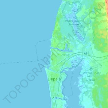
Name: Liepaja topographic map, elevation, terrain.
Location: Liepaja, Courland, Latvia (56.46531 20.96212 56.60905 21.10574)
Average elevation: 2 m
Minimum elevation: -3 m
Maximum elevation: 34 m
Other topographic maps
Click on a map to view its topography, its elevation and its terrain.
Skrunda
Latvia > Courland > Kuldīgas novads
Skrunda, Kuldīgas novads, Courland, LV-3326, Latvia
Average elevation: 37 m
Kolka
Latvia > Courland > Talsu novads > Kolkas pagasts
Kolka, Kolkas pagasts, Talsu novads, Courland, Latvia
Average elevation: 3 m
Līkupēni
Latvia > Courland > Saldus novads > Rubas pagasts
Līkupēni, Rubas pagasts, Saldus novads, Courland, LV-3892, Latvia
Average elevation: 80 m
Ragaciems
Latvia > Courland > Tukuma novads
Ragaciems, Tukuma novads, Courland, Latvia
Average elevation: 2 m
Engure
Latvia > Courland > Ventspils novads
Engure, Ventspils novads, Courland, Latvia
Average elevation: 23 m
Engure
Latvia > Courland > Ventspils novads
Engure, Kalnenieki, Ventspils novads, Courland, Latvia
Average elevation: 25 m
Alsunga
Latvia > Courland > Kuldīgas novads > Alsungas pagasts
Alsunga, Alsungas pagasts, Kuldīgas novads, Courland, LV-3306, Latvia
Average elevation: 35 m
Engures novads
Latvia > Courland > Tukuma novads
Engures novads, Tukuma novads, Courland, Latvia
Average elevation: 23 m
Pāvilosta
Latvia > Courland > Dienvidkurzemes novads
Pāvilosta, Dienvidkurzemes novads, Courland, LV-3466, Latvia
Average elevation: 8 m