
Skrunda topographic map
Interactive map
Click on the map to display elevation.
About this map
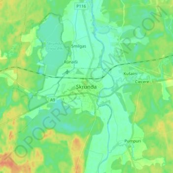
Name: Skrunda topographic map, elevation, terrain.
Location: Skrunda, Kuldīgas novads, Courland, LV-3326, Latvia (56.63684 21.97561 56.71684 22.05561)
Average elevation: 37 m
Minimum elevation: 23 m
Maximum elevation: 67 m
Other topographic maps
Click on a map to view its topography, its elevation and its terrain.
Alsunga
Latvia > Courland > Kuldīgas novads > Alsungas pagasts
Alsunga, Alsungas pagasts, Kuldīgas novads, Courland, LV-3306, Latvia
Average elevation: 35 m