
Make a donation
Oregon topographic map
Click on the map to display elevation.
Make a donation
Oregon
Oregon is 295 miles (475 km) north to south at longest distance, and 395 miles (636 km) east to west. With an area of 98,381 square miles (254,810 km2), Oregon is slightly larger than the United Kingdom. It is the ninth largest state in the U.S. Oregon's highest point is the summit of Mount Hood, at 11,249 feet (3,429 m), and its lowest point is the sea level of the Pacific Ocean along the Oregon Coast. Oregon's mean elevation is 3,300 feet (1,006 m). Crater Lake National Park, the state's only national park, is the site of the deepest lake in the U.S. at 1,943 feet (592 m). Oregon claims the D River as the shortest river in the world, though the state of Montana makes the same claim of its Roe River. Oregon is also home to Mill Ends Park (in Portland), the smallest park in the world at 452 square inches (0.29 m2).
Make a donation
About this map
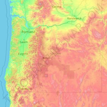
Name: Oregon topographic map, elevation, terrain.
Location: Oregon, United States (41.99179 -124.70354 46.29239 -116.46315)
Average elevation: 938 m
Minimum elevation: -3 m
Maximum elevation: 4,170 m
Make a donation
Other topographic maps
Click on a map to view its topography, its elevation and its terrain.
Nash Hill Reservoir Dam
United States > Massachusetts > Hampden County > Ludlow
Average elevation: 89 m
Make a donation
Make a donation
Two Creeks Buried Forest State Natural Area
United States > Wisconsin > Kewaunee County
Average elevation: 187 m
Make a donation
Make a donation
Make a donation
Groveland
United States > California > Tuolumne County
Groveland is a census-designated place (CDP) in Tuolumne County, California. Groveland sits at an elevation of 3,136 feet (956 m). The 2020 United States census reported Groveland's population was 540.
Average elevation: 898 m
Vail
United States > Colorado > Eagle County
Vail's average elevation is 8,150 feet (2,480 m) above sea level. The town has a total area of 4.5 square miles (12 km2), with no lakes (there is, however, at least one pond). Gore Creek flows from east to west through the center of town.
Average elevation: 2,953 m
Make a donation
Barlow Hill
United States > Pennsylvania > Tioga County > Charleston Township
Average elevation: 473 m
Make a donation
Roaring Brook
United States > Vermont > Rutland County > Killington > Sherburne Center
Average elevation: 504 m
Cherry Ridge
United States > Colorado > Arapahoe County > Cherry Hills Village
Average elevation: 1,680 m
Make a donation
Make a donation
Make a donation
Mississippi River
United States > Louisiana > West Feliciana Parish
The uppermost lock and dam on the Upper Mississippi River is the Upper St. Anthony Falls Lock and Dam in Minneapolis. Above the dam, the river's elevation is 799 feet (244 m). Below the dam, the river's elevation is 750 feet (230 m). This 49-foot (15 m) drop is the largest of all the Mississippi River locks…
Average elevation: 13 m