
Thank you for supporting this site ❤️
Make a donation
Make a donation
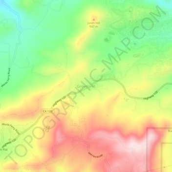
Groveland topographic map
Click on the map to display elevation.
Thank you for supporting this site ❤️
Make a donation
Make a donation
Groveland
Groveland is a census-designated place (CDP) in Tuolumne County, California. Groveland sits at an elevation of 3,136 feet (956 m). The 2020 United States census reported Groveland's population was 540.
Thank you for supporting this site ❤️
Make a donation
Make a donation
About this map
Name: Groveland topographic map, elevation, terrain.
Average elevation: 898 m
Minimum elevation: 706 m
Maximum elevation: 1,097 m
Thank you for supporting this site ❤️
Make a donation
Make a donation