
Bali topographic map
Interactive map
Click on the map to display elevation.
About this map
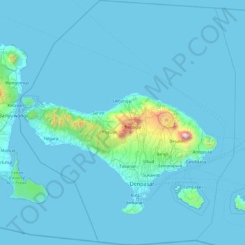
Name: Bali topographic map, elevation, terrain.
Location: Bali, Lesser Sunda Islands, Indonesia (-9.05023 114.41268 -7.46280 115.83242)
Average elevation: 88 m
Minimum elevation: -1 m
Maximum elevation: 2,917 m
Bali's central mountains include several peaks over 2,000 metres (6,600 feet) in elevation and active volcanoes such as Mount Batur. The highest is Mount Agung (3,031 m; 9,944 ft), known as the "mother mountain", which is an active volcano rated as one of the world's most likely sites for a massive eruption within the next 100 years. In late 2017 Mount Agung started erupting and large numbers of people were evacuated, temporarily closing the island's airport. Mountains range from centre to the eastern side, with Mount Agung the easternmost peak. Bali's volcanic nature has contributed to its exceptional fertility and its tall mountain ranges provide the high rainfall that supports the highly productive agriculture sector. South of the mountains is a broad, steadily descending area where most of Bali's large rice crop is grown. The northern side of the mountains slopes more steeply to the sea and is the main coffee-producing area of the island, along with rice, vegetables, and cattle. The longest river, Ayung River, flows approximately 75 km (47 mi) (see List of rivers of Bali).
Other topographic maps
Click on a map to view its topography, its elevation and its terrain.
Pinrang
Pinrang, South Sulawesi, Sulawesi, Indonesia
Average elevation: 334 m
Winongan Kidul
Indonesia > East Java > Pasuruan
Winongan Kidul, Pasuruan, East Java, Java, 67181, Indonesia
Average elevation: 14 m
Mancingan
Indonesia > Bali > Gianyar > Tampak Siring
Mancingan, Tampak Siring, Gianyar, Bali, Lesser Sunda Islands, 80661, Indonesia
Average elevation: 513 m
Kelapa Nunggal
Kelapa Nunggal, Klapanunggal, Bogor, West Java, Java, Indonesia
Average elevation: 236 m
Mount Ibu
Indonesia > North Maluku > Halmahera Barat
Mount Ibu, Halmahera Barat, North Maluku, Maluku, Indonesia
Average elevation: 951 m
Weninggalih
Weninggalih, Jonggol, Bogor, West Java, Java, Indonesia
Average elevation: 78 m
Kayangan
Indonesia > Central Java > Karanganyar > Karanganyar
Kayangan, Karanganyar, Central Java, Java, 57714, Indonesia
Average elevation: 160 m
Kutai Kartanegara
Kutai Kartanegara, East Kalimantan, Kalimantan, Indonesia
Average elevation: 217 m
Hulu Sungai Utara
Hulu Sungai Utara, South Kalimantan, Kalimantan, Indonesia
Average elevation: 10 m
Antapani Kidul
Indonesia > West Java > Bandung
Antapani Kidul, Antapani, Bandung, West Java, Java, 40291, Indonesia
Average elevation: 680 m
Gunung Gede
Indonesia > East Java > Jombang
Gunung Gede, Jombang, East Java, Java, Indonesia
Average elevation: 1,667 m
Sukanagara
Indonesia > West Java > Bandung Regency
Sukanagara, Bandung Regency, West Java, Java, 40912, Indonesia
Average elevation: 949 m
Salagedang
Indonesia > West Java > Cianjur
Salagedang, Cianjur, West Java, Java, Indonesia
Average elevation: 913 m
Ciganjur
Indonesia > Special Capital Region of Jakarta
Ciganjur, Jagakarsa, South Jakarta, Special Capital Region of Jakarta, Java, 16431, Indonesia
Average elevation: 58 m
Loji
Indonesia > Central Sulawesi > Parigi Moutong Regency
Loji, Parigi Moutong Regency, Central Sulawesi, Sulawesi, 94471, Indonesia
Average elevation: 17 m
Gunung Mas
Gunung Mas, Cisarua, Bogor, West Java, Java, 43253, Indonesia
Average elevation: 1,398 m
Gunung Mas
Indonesia > Central Kalimantan
Gunung Mas, Central Kalimantan, Kalimantan, Indonesia
Average elevation: 152 m
Cibeber
Indonesia > West Java > Purwakarta Regency
Cibeber, Purwakarta Regency, West Java, Java, 41175, Indonesia
Average elevation: 573 m
Parungseah
Indonesia > West Java > Sukabumi
Parungseah, Sukabumi, West Java, Java, 43135, Indonesia
Average elevation: 646 m
Cireunghas
Indonesia > West Java > Sukabumi
Cireunghas, Sukabumi, West Java, Java, Indonesia
Average elevation: 628 m
Desa Cisadon
Desa Cisadon, Babakan Madang, Bogor, West Java, Java, Indonesia
Average elevation: 1,144 m
Banguntapan
Indonesia > Special Region of Yogyakarta > Bantul Regency
Banguntapan, Bantul Regency, Special Region of Yogyakarta, Java, 55198, Indonesia
Average elevation: 100 m
Alor
Indonesia > East Nusa Tenggara
Alor, East Nusa Tenggara, Lesser Sunda Islands, 85811, Indonesia
Average elevation: 104 m
Kepulauan Barat Daya
Kepulauan Barat Daya, Moluccas, Maluku, Indonesia
Average elevation: 0 m
Nagrak
Indonesia > West Java > Bandung Regency
Nagrak, Bandung Regency, West Java, Java, 40311, Indonesia
Average elevation: 714 m
Mangkubumi
Indonesia > West Java > Tasikmalaya
Mangkubumi, Tasikmalaya, West Java, Java, 46181, Indonesia
Average elevation: 370 m
Dadapayu
Indonesia > Special Region of Yogyakarta > Gunung Kidul Regency
Dadapayu, Semanu, Gunung Kidul Regency, Special Region of Yogyakarta, Java, Indonesia
Average elevation: 302 m
Ngawen
Indonesia > Special Region of Yogyakarta > Gunung Kidul Regency
Ngawen, Gunung Kidul Regency, Special Region of Yogyakarta, Java, 55853, Indonesia
Average elevation: 228 m