
Ubrug topographic map
Interactive map
Click on the map to display elevation.
About this map
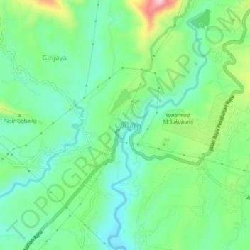
Name: Ubrug topographic map, elevation, terrain.
Location: Ubrug, Sukabumi, West Java, Java, 43115, Indonesia (-6.96777 106.73591 -6.92777 106.77591)
Average elevation: 309 m
Minimum elevation: 232 m
Maximum elevation: 487 m
Other topographic maps
Click on a map to view its topography, its elevation and its terrain.
Cireunghas
Indonesia > West Java > Sukabumi
Cireunghas, Sukabumi, West Java, Java, Indonesia
Average elevation: 628 m
Kertaraharja
Indonesia > West Java > Sukabumi
Kertaraharja, Sukabumi, West Java, Java, 43196, Indonesia
Average elevation: 380 m