
Bekasi topographic map
Interactive map
Click on the map to display elevation.
Bekasi
The City of Bekasi is a part of the Bekasi river basin, located in the downstream area of the basin with slopes ranging from 0 to 2% and elevations between 11 meters to 81 meters above sea level. The city of Bekasi is part of the Bekasi river basin and is located in the downstream area of the basin, with a slope ranging from 0 to 2% and elevations between 11 meters to 81 meters above sea level. This topographical condition leads to frequent flooding in many areas of Bekasi, especially during the rainy season, such as in the districts of Jatiasih, East Bekasi, Rawalumbu, South Bekasi, West Bekasi, and Pondok Melati.
About this map
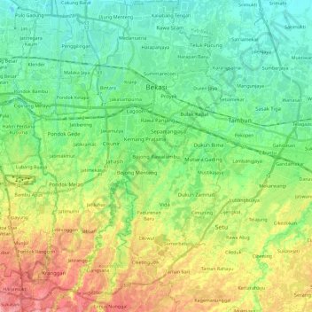
Name: Bekasi topographic map, elevation, terrain.
Location: Bekasi, West Java, Java, Indonesia (-6.39860 106.89773 -6.17177 107.04238)
Average elevation: 32 m
Minimum elevation: -1 m
Maximum elevation: 91 m
Other topographic maps
Click on a map to view its topography, its elevation and its terrain.