
Banten topographic map
Interactive map
Click on the map to display elevation.
Banten
The topography of Banten province at an altitude ranging from 0–1000 m asl. In general the topography of Banten is mostly low land which ranges between 0–200 m above sea level, located in Cilegon, Tangerang, Pandeglang Regency, and most of the Serang Regency. The Central region of the Lebak Regency and Pandeglang Regency has a height ranging from 201 m to 2000 m and the Eastern region of the Lebak Regency has an altitude 501–2000 m located at the summit of Mount Sanggabuana and Mount Halimun.
About this map
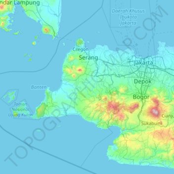
Name: Banten topographic map, elevation, terrain.
Location: Banten, Indonesia (-7.45659 104.65132 -5.49964 106.78001)
Average elevation: 57 m
Minimum elevation: -1 m
Maximum elevation: 1,922 m
Other topographic maps
Click on a map to view its topography, its elevation and its terrain.