Geolocate

Lebak topographic map

Interactive map

Click on the map to display elevation.

About this map

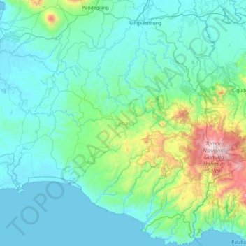
Name: Lebak topographic map, elevation, terrain.

Location: Lebak, Banten, Indonesia (-6.99848 105.86306 -6.28843 106.52629)

Average elevation: 247 m

Minimum elevation: -1 m

Maximum elevation: 1,901 m

Other topographic maps

Click on a map to view its topography, its elevation and its terrain.

Legok

Indonesia > Banten > Legok

Average elevation: 37 m

Cipadu

Indonesia > Banten > Kota Tangerang > Cipadu

Average elevation: 23 m

Bojong Nangka

Indonesia > Banten > Bojong Nangka

Average elevation: 31 m

Bencongan

Indonesia > Banten > Tangerang > Bencongan

Average elevation: 27 m

Karawaci

Indonesia > Banten > Kota Tangerang > Karawaci

Average elevation: 18 m

Ciputat

Indonesia > Banten > South Tangerang > Ciputat

Average elevation: 45 m

Mekarsari

Indonesia > Banten > Mekarsari

Average elevation: 78 m