
Village of Bloomingburg topographic map
Interactive map
Click on the map to display elevation.
About this map
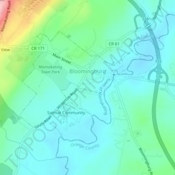
Name: Village of Bloomingburg topographic map, elevation, terrain.
Average elevation: 164 m
Minimum elevation: 127 m
Maximum elevation: 299 m
Other topographic maps
Click on a map to view its topography, its elevation and its terrain.
Harris
United States > New York > Sullivan County
Harris, Town of Thompson, Sullivan County, New York, 12742, United States
Average elevation: 396 m
Claryville
United States > New York > Sullivan County > Town of Neversink
Claryville, Town of Neversink, Sullivan County, New York, 12725, United States
Average elevation: 628 m
Eldred
United States > New York > Sullivan County
Eldred, Town of Highland, Sullivan County, New York, United States
Average elevation: 351 m
Debruce
United States > New York > Sullivan County > Town of Rockland
Debruce, Town of Rockland, Sullivan County, New York, 12768, United States
Average elevation: 600 m
Unionville
United States > New York > Sullivan County > Town of Neversink
Unionville, Grahamsville, Town of Neversink, Sullivan County, New York, 12740, United States
Average elevation: 450 m
Town of Callicoon
United States > New York > Sullivan County
Town of Callicoon, Sullivan County, New York, United States
Average elevation: 513 m
Deckertown
United States > New York > Sullivan County > Town of Rockland
Deckertown, Town of Rockland, Sullivan County, New York, 12758, United States
Average elevation: 531 m
Mongaup Valley
United States > New York > Sullivan County > Town of Bethel
Mongaup Valley, Town of Bethel, Sullivan County, New York, United States
Average elevation: 380 m
Anderson
United States > New York > Sullivan County > Town of Rockland
Anderson, Town of Rockland, Sullivan County, New York, 12768, United States
Average elevation: 612 m
Long Eddy
United States > New York > Sullivan County
Long Eddy, Town of Fremont, Sullivan County, New York, United States
Average elevation: 388 m
Winterton
United States > New York > Sullivan County
Winterton, Town of Mamakating, Sullivan County, New York, 10932, United States
Average elevation: 225 m
Grahamsville
United States > New York > Sullivan County > Town of Neversink
Grahamsville, Town of Neversink, Sullivan County, New York, United States
Average elevation: 397 m
Village of Wurtsboro
United States > New York > Sullivan County
Village of Wurtsboro, Town of Mamakating, Sullivan County, New York, United States
Average elevation: 204 m
Barryville
United States > New York > Sullivan County
Barryville, Town of Highland, Sullivan County, New York, United States
Average elevation: 272 m
Mountain Dale
United States > New York > Sullivan County > Town of Fallsburg
Mountain Dale, Town of Fallsburg, Sullivan County, New York, 12763, United States
Average elevation: 363 m
Mohican Lake
United States > New York > Sullivan County
Mohican Lake, Town of Lumberland, Sullivan County, New York, 12743, United States
Average elevation: 402 m
Shawangunk Ridge
United States > New York > Sullivan County
Shawangunk Ridge, Sullivan County, New York, United States
Average elevation: 256 m
Town of Fremont
United States > New York > Sullivan County
Town of Fremont, Sullivan County, New York, United States
Average elevation: 484 m
Town of Cochecton
United States > New York > Sullivan County
Town of Cochecton, Sullivan County, New York, United States
Average elevation: 335 m
Callicoon
United States > New York > Sullivan County
Callicoon, Town of Delaware, Sullivan County, New York, United States
Average elevation: 311 m
Village of Woodridge
United States > New York > Sullivan County > Town of Fallsburg
Village of Woodridge, Town of Fallsburg, Sullivan County, New York, 12789, United States
Average elevation: 383 m
Village of Monticello
United States > New York > Sullivan County
Village of Monticello, Town of Thompson, Sullivan County, New York, 12701, United States
Average elevation: 444 m
Willowemoc
United States > New York > Sullivan County > Town of Neversink
Willowemoc, Town of Neversink, Sullivan County, New York, United States
Average elevation: 630 m
Evens Lake
United States > New York > Sullivan County > Town of Fallsburg > Loch Sheldrake
Evens Lake, Loch Sheldrake, Town of Fallsburg, Sullivan County, New York, 12747, United States
Average elevation: 443 m
Rock Hill
United States > New York > Sullivan County
Rock Hill, Town of Thompson, Sullivan County, New York, 12775, United States
Average elevation: 435 m
Summitville
United States > New York > Sullivan County
Summitville, Town of Mamakating, Sullivan County, New York, 12781, United States
Average elevation: 270 m
Swan Lake
United States > New York > Sullivan County > Town of Liberty
Swan Lake, Town of Liberty, Sullivan County, New York, United States
Average elevation: 436 m
Mongaup
United States > New York > Sullivan County
Mongaup, Town of Lumberland, Sullivan County, New York, 18340, United States
Average elevation: 252 m
Town of Fallsburg
United States > New York > Sullivan County
Town of Fallsburg, Sullivan County, New York, United States
Average elevation: 408 m
Town of Forestburgh
United States > New York > Sullivan County
Town of Forestburgh, Sullivan County, New York, 12777, United States
Average elevation: 399 m
Fallsburg
United States > New York > Sullivan County
Fallsburg, Town of Fallsburg, Sullivan County, New York, 12733, United States
Average elevation: 404 m
White Sulphur Springs
United States > New York > Sullivan County > Town of Liberty > White Sulphur Springs
White Sulphur Springs, Town of Liberty, Sullivan County, New York, 12787, United States
Average elevation: 455 m
Town of Bethel
United States > New York > Sullivan County
Town of Bethel, Sullivan County, New York, United States
Average elevation: 390 m
Livingston Manor
United States > New York > Sullivan County > Town of Rockland
Livingston Manor, Town of Rockland, Sullivan County, New York, 12758, United States
Average elevation: 515 m
Grahamsville
United States > New York > Sullivan County > Grahamsville
Grahamsville, Town of Neversink, Sullivan County, New York, 12740, United States
Average elevation: 404 m
Parkston
United States > New York > Sullivan County > Town of Rockland > Parkston
Parkston, Town of Rockland, Sullivan County, New York, 12758, United States
Average elevation: 567 m
Town of Neversink
United States > New York > Sullivan County
Town of Neversink, Sullivan County, New York, United States
Average elevation: 563 m
Roscoe
United States > New York > Sullivan County > Town of Rockland
Roscoe, Town of Rockland, Sullivan County, New York, United States
Average elevation: 487 m
Town of Mamakating
United States > New York > Sullivan County
Town of Mamakating, Sullivan County, New York, United States
Average elevation: 316 m
Hurleyville
United States > New York > Sullivan County > Hurleyville
Hurleyville, Town of Fallsburg, Sullivan County, New York, 12747, United States
Average elevation: 431 m
Village of Liberty
United States > New York > Sullivan County
Village of Liberty, Town of Liberty, Sullivan County, New York, 12754, United States
Average elevation: 496 m
Town of Liberty
United States > New York > Sullivan County
Town of Liberty, Sullivan County, New York, United States
Average elevation: 510 m
Fallsburg
United States > New York > Sullivan County > Fallsburg
Fallsburg, Town of Fallsburg, Sullivan County, New York, 12733, United States
Average elevation: 399 m
Parksville
United States > New York > Sullivan County > Town of Liberty
Parksville, Town of Liberty, Sullivan County, New York, 12768, United States
Average elevation: 578 m
Town of Tusten
United States > New York > Sullivan County
Town of Tusten, Sullivan County, New York, 12764, United States
Average elevation: 342 m
Narrowsburg
United States > New York > Sullivan County > Town of Tusten
Narrowsburg, Town of Tusten, Sullivan County, New York, United States
Average elevation: 261 m
Town of Rockland
United States > New York > Sullivan County
Town of Rockland, Sullivan County, New York, United States
Average elevation: 575 m
Lake Superior State Park
United States > New York > Sullivan County > Town of Bethel
Lake Superior State Park, Town of Bethel, Sullivan County, New York, 12720, United States
Average elevation: 402 m