
Town of Fremont topographic map
Interactive map
Click on the map to display elevation.
About this map
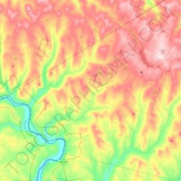
Name: Town of Fremont topographic map, elevation, terrain.
Location: Town of Fremont, Sullivan County, New York, United States (41.79325 -75.14544 41.92400 -74.92923)
Average elevation: 484 m
Minimum elevation: 220 m
Maximum elevation: 721 m
The climate of the town is typical of the interior northeast. Made up of hills of about 2,000 ft. in elevation and valleys under 1,000 ft. The majority of the town is forested with open fields scattered about.
Other topographic maps
Click on a map to view its topography, its elevation and its terrain.
Harris
United States > New York > Sullivan County
Harris, Town of Thompson, Sullivan County, New York, 12742, United States
Average elevation: 396 m
Claryville
United States > New York > Sullivan County > Town of Neversink
Claryville, Town of Neversink, Sullivan County, New York, 12725, United States
Average elevation: 628 m
Eldred
United States > New York > Sullivan County
Eldred, Town of Highland, Sullivan County, New York, United States
Average elevation: 351 m
Debruce
United States > New York > Sullivan County > Town of Rockland
Debruce, Town of Rockland, Sullivan County, New York, 12768, United States
Average elevation: 600 m
Unionville
United States > New York > Sullivan County > Town of Neversink
Unionville, Grahamsville, Town of Neversink, Sullivan County, New York, 12740, United States
Average elevation: 450 m
Town of Callicoon
United States > New York > Sullivan County
Town of Callicoon, Sullivan County, New York, United States
Average elevation: 513 m
Deckertown
United States > New York > Sullivan County > Town of Rockland
Deckertown, Town of Rockland, Sullivan County, New York, 12758, United States
Average elevation: 531 m
Mongaup Valley
United States > New York > Sullivan County > Town of Bethel
Mongaup Valley, Town of Bethel, Sullivan County, New York, United States
Average elevation: 380 m
Anderson
United States > New York > Sullivan County > Town of Rockland
Anderson, Town of Rockland, Sullivan County, New York, 12768, United States
Average elevation: 612 m
Long Eddy
United States > New York > Sullivan County
Long Eddy, Town of Fremont, Sullivan County, New York, United States
Average elevation: 388 m
Winterton
United States > New York > Sullivan County
Winterton, Town of Mamakating, Sullivan County, New York, 10932, United States
Average elevation: 225 m
Grahamsville
United States > New York > Sullivan County > Town of Neversink
Grahamsville, Town of Neversink, Sullivan County, New York, United States
Average elevation: 397 m
Village of Wurtsboro
United States > New York > Sullivan County
Village of Wurtsboro, Town of Mamakating, Sullivan County, New York, United States
Average elevation: 204 m
Barryville
United States > New York > Sullivan County
Barryville, Town of Highland, Sullivan County, New York, United States
Average elevation: 272 m
Mountain Dale
United States > New York > Sullivan County > Town of Fallsburg
Mountain Dale, Town of Fallsburg, Sullivan County, New York, 12763, United States
Average elevation: 363 m
Mohican Lake
United States > New York > Sullivan County
Mohican Lake, Town of Lumberland, Sullivan County, New York, 12743, United States
Average elevation: 402 m
Shawangunk Ridge
United States > New York > Sullivan County
Shawangunk Ridge, Sullivan County, New York, United States
Average elevation: 256 m
Town of Cochecton
United States > New York > Sullivan County
Town of Cochecton, Sullivan County, New York, United States
Average elevation: 335 m
Callicoon
United States > New York > Sullivan County
Callicoon, Town of Delaware, Sullivan County, New York, United States
Average elevation: 311 m
Village of Woodridge
United States > New York > Sullivan County > Town of Fallsburg
Village of Woodridge, Town of Fallsburg, Sullivan County, New York, 12789, United States
Average elevation: 383 m
Village of Monticello
United States > New York > Sullivan County
Village of Monticello, Town of Thompson, Sullivan County, New York, 12701, United States
Average elevation: 444 m
Village of Bloomingburg
United States > New York > Sullivan County
Village of Bloomingburg, Town of Mamakating, Sullivan County, New York, United States
Average elevation: 164 m
Willowemoc
United States > New York > Sullivan County > Town of Neversink
Willowemoc, Town of Neversink, Sullivan County, New York, United States
Average elevation: 630 m
Evens Lake
United States > New York > Sullivan County > Town of Fallsburg > Loch Sheldrake
Evens Lake, Loch Sheldrake, Town of Fallsburg, Sullivan County, New York, 12747, United States
Average elevation: 443 m
Rock Hill
United States > New York > Sullivan County
Rock Hill, Town of Thompson, Sullivan County, New York, 12775, United States
Average elevation: 435 m
Summitville
United States > New York > Sullivan County
Summitville, Town of Mamakating, Sullivan County, New York, 12781, United States
Average elevation: 270 m
Swan Lake
United States > New York > Sullivan County > Town of Liberty
Swan Lake, Town of Liberty, Sullivan County, New York, United States
Average elevation: 436 m
Mongaup
United States > New York > Sullivan County
Mongaup, Town of Lumberland, Sullivan County, New York, 18340, United States
Average elevation: 252 m
Town of Fallsburg
United States > New York > Sullivan County
Town of Fallsburg, Sullivan County, New York, United States
Average elevation: 408 m
Town of Forestburgh
United States > New York > Sullivan County
Town of Forestburgh, Sullivan County, New York, 12777, United States
Average elevation: 399 m
Fallsburg
United States > New York > Sullivan County
Fallsburg, Town of Fallsburg, Sullivan County, New York, 12733, United States
Average elevation: 404 m
White Sulphur Springs
United States > New York > Sullivan County > Town of Liberty > White Sulphur Springs
White Sulphur Springs, Town of Liberty, Sullivan County, New York, 12787, United States
Average elevation: 455 m
Town of Bethel
United States > New York > Sullivan County
Town of Bethel, Sullivan County, New York, United States
Average elevation: 390 m
Livingston Manor
United States > New York > Sullivan County > Town of Rockland
Livingston Manor, Town of Rockland, Sullivan County, New York, 12758, United States
Average elevation: 515 m
Grahamsville
United States > New York > Sullivan County > Grahamsville
Grahamsville, Town of Neversink, Sullivan County, New York, 12740, United States
Average elevation: 404 m
Parkston
United States > New York > Sullivan County > Town of Rockland > Parkston
Parkston, Town of Rockland, Sullivan County, New York, 12758, United States
Average elevation: 567 m
Town of Neversink
United States > New York > Sullivan County
Town of Neversink, Sullivan County, New York, United States
Average elevation: 563 m
Roscoe
United States > New York > Sullivan County > Town of Rockland
Roscoe, Town of Rockland, Sullivan County, New York, United States
Average elevation: 487 m
Town of Mamakating
United States > New York > Sullivan County
Town of Mamakating, Sullivan County, New York, United States
Average elevation: 316 m
Hurleyville
United States > New York > Sullivan County > Hurleyville
Hurleyville, Town of Fallsburg, Sullivan County, New York, 12747, United States
Average elevation: 431 m
Village of Liberty
United States > New York > Sullivan County
Village of Liberty, Town of Liberty, Sullivan County, New York, 12754, United States
Average elevation: 496 m
Town of Liberty
United States > New York > Sullivan County
Town of Liberty, Sullivan County, New York, United States
Average elevation: 510 m
Fallsburg
United States > New York > Sullivan County > Fallsburg
Fallsburg, Town of Fallsburg, Sullivan County, New York, 12733, United States
Average elevation: 399 m
Parksville
United States > New York > Sullivan County > Town of Liberty
Parksville, Town of Liberty, Sullivan County, New York, 12768, United States
Average elevation: 578 m
Town of Tusten
United States > New York > Sullivan County
Town of Tusten, Sullivan County, New York, 12764, United States
Average elevation: 342 m
Narrowsburg
United States > New York > Sullivan County > Town of Tusten
Narrowsburg, Town of Tusten, Sullivan County, New York, United States
Average elevation: 261 m
Town of Rockland
United States > New York > Sullivan County
Town of Rockland, Sullivan County, New York, United States
Average elevation: 575 m
Lake Superior State Park
United States > New York > Sullivan County > Town of Bethel
Lake Superior State Park, Town of Bethel, Sullivan County, New York, 12720, United States
Average elevation: 402 m