
Make a donation
Montana topographic map
Click on the map to display elevation.
Make a donation
Montana
Montana's topography is marked by dramatic contrasts, offering a rich tapestry of landscapes. The state is divided into three main regions: the vast, rolling plains in the east, the rugged Rocky Mountains in the west, and the transition zone between these two. The eastern plains are part of the Great Plains, characterized by expansive grasslands, gently rolling hills, and wide river valleys, with minimal precipitation and semi-arid conditions. These plains are interrupted by isolated mountain ranges such as the Bear Paw and Little Rocky Mountains. The western part of the state is dominated by the Rocky Mountains, featuring steep, forested slopes, narrow valleys, and high peaks, including Granite Peak, which rises to 12,807 feet ((3,904 meters). Here, snow-covered mountains, active glaciers, and clear, cold lakes are common, particularly in areas like Glacier National Park. Between these extremes, the Central Front forms a transitional landscape with prairies, badlands, and smaller mountain ranges, bridging the plains and the mountains.
Make a donation
About this map
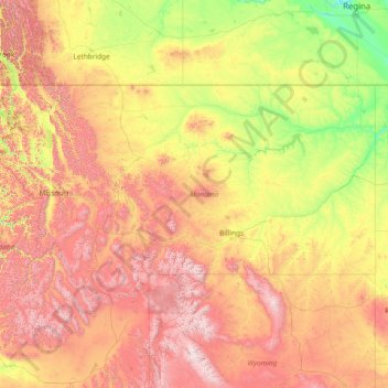
Name: Montana topographic map, elevation, terrain.
Location: Montana, United States (44.35792 -116.04923 49.00111 -104.03956)
Average elevation: 1,357 m
Minimum elevation: 552 m
Maximum elevation: 4,034 m
Make a donation
Other topographic maps
Click on a map to view its topography, its elevation and its terrain.
Nash Hill Reservoir Dam
United States > Massachusetts > Hampden County > Ludlow
Average elevation: 89 m
Make a donation
Roaring Brook
United States > Vermont > Rutland County > Killington > Sherburne Center
Average elevation: 504 m
Make a donation
Make a donation
Make a donation
Barlow Hill
United States > Pennsylvania > Tioga County > Charleston Township
Average elevation: 473 m
Two Creeks Buried Forest State Natural Area
United States > Wisconsin > Kewaunee County
Average elevation: 187 m
Make a donation
Make a donation
Groveland
United States > California > Tuolumne County
Groveland is a census-designated place (CDP) in Tuolumne County, California. Groveland sits at an elevation of 3,136 feet (956 m). The 2020 United States census reported Groveland's population was 540.
Average elevation: 898 m
Make a donation
Vail
United States > Colorado > Eagle County
Vail's average elevation is 8,150 feet (2,480 m) above sea level. The town has a total area of 4.5 square miles (12 km2), with no lakes (there is, however, at least one pond). Gore Creek flows from east to west through the center of town.
Average elevation: 2,953 m
Cherry Ridge
United States > Colorado > Arapahoe County > Cherry Hills Village
Average elevation: 1,680 m
Make a donation
Make a donation
Mississippi River
United States > Louisiana > West Feliciana Parish
The uppermost lock and dam on the Upper Mississippi River is the Upper St. Anthony Falls Lock and Dam in Minneapolis. Above the dam, the river's elevation is 799 feet (244 m). Below the dam, the river's elevation is 750 feet (230 m). This 49-foot (15 m) drop is the largest of all the Mississippi River locks…
Average elevation: 13 m
Make a donation