
East Godavari topographic map
Interactive map
Click on the map to display elevation.
About this map
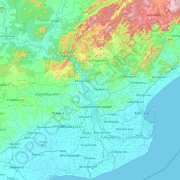
Name: East Godavari topographic map, elevation, terrain.
Location: East Godavari, Andhra Pradesh, India (16.31028 80.88549 18.00572 82.59509)
Average elevation: 159 m
Minimum elevation: -4 m
Maximum elevation: 1,420 m
Other topographic maps
Click on a map to view its topography, its elevation and its terrain.
Jaggayapeta
India > Andhra Pradesh > Vepada
Jaggayapeta, Vepada, Vizianagaram District, Andhra Pradesh, 535161, India
Average elevation: 62 m
Nellore
India > Andhra Pradesh > Nellore
Nellore, Sri Potti Sriramulu Nellore, Andhra Pradesh, 524002, India
Average elevation: 17 m