
Krishna topographic map
Interactive map
Click on the map to display elevation.
About this map
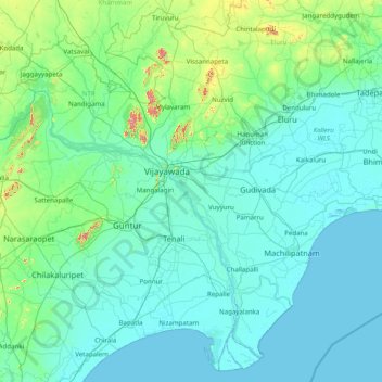
Name: Krishna topographic map, elevation, terrain.
Location: Krishna, Andhra Pradesh, India (15.71226 80.00844 17.15318 81.57061)
Average elevation: 42 m
Minimum elevation: -2 m
Maximum elevation: 526 m
Other topographic maps
Click on a map to view its topography, its elevation and its terrain.
Jaggayapeta
India > Andhra Pradesh > Vepada
Jaggayapeta, Vepada, Vizianagaram District, Andhra Pradesh, 535161, India
Average elevation: 62 m
Nellore
India > Andhra Pradesh > Nellore
Nellore, Sri Potti Sriramulu Nellore, Andhra Pradesh, 524002, India
Average elevation: 17 m