
Andhra Pradesh topographic map
Interactive map
Click on the map to display elevation.
About this map
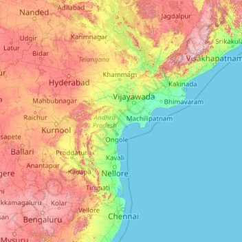
Name: Andhra Pradesh topographic map, elevation, terrain.
Location: Andhra Pradesh, India (12.62272 76.76113 19.16633 84.76474)
Average elevation: 269 m
Minimum elevation: -1 m
Maximum elevation: 1,463 m
Andhra Pradesh topographical map
Other topographic maps
Click on a map to view its topography, its elevation and its terrain.
Jaggayapeta
India > Andhra Pradesh > Vepada
Jaggayapeta, Vepada, Vizianagaram District, Andhra Pradesh, 535161, India
Average elevation: 62 m
Nellore
India > Andhra Pradesh > Nellore
Nellore, Sri Potti Sriramulu Nellore, Andhra Pradesh, 524002, India
Average elevation: 17 m