
Île Norfolk topographic map
Interactive map
Click on the map to display elevation.
About this map
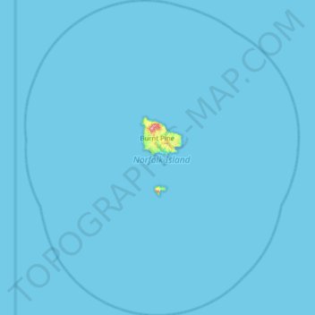
Name: Île Norfolk topographic map, elevation, terrain.
Location: Île Norfolk, Australie (-29.33707 167.68567 -28.79366 168.22613)
Average elevation: 1 m
Minimum elevation: 0 m
Maximum elevation: 309 m
Other topographic maps
Click on a map to view its topography, its elevation and its terrain.
Hawkesbury City Council
Australie > Nouvelle Galles du Sud
Hawkesbury City Council, Nouvelle Galles du Sud, Australie
Average elevation: 251 m
Mount Krungle Bungle
Australie > Nouvelle Galles du Sud
Mount Krungle Bungle, Oberon Council, Nouvelle Galles du Sud, Australie
Average elevation: 1,138 m
Fritsch Holzer Park
Australie > Victoria > Melbourne
Fritsch Holzer Park, Hawthorn East, Melbourne, City of Boroondara, Victoria, 3123, Australie
Average elevation: 52 m
Sydney
Australie > Nouvelle Galles du Sud
Sydney, Council of the City of Sydney, Nouvelle Galles du Sud, Australie
Average elevation: 53 m
City Of Gosnells
Australie > Australie occidentale
City Of Gosnells, Australie occidentale, Australie
Average elevation: 90 m
Mount Napier
Mount Napier, Shire of Southern Grampians, Victoria, 3301, Australie
Average elevation: 213 m
Whitsundays
Whitsundays, Whitsunday Regional, Queensland, Australie
Average elevation: 15 m
Tilley Road (no. 73) Park
Tilley Road (no. 73) Park, Wakerley, Greater Brisbane, Queensland, 4154, Australie
Average elevation: 17 m
Lord Howe Island
Australie > Nouvelle Galles du Sud > Lord Howe Island
Lord Howe Island, Nouvelle Galles du Sud, 2898, Australie
Average elevation: 27 m
City of Fremantle
Australie > Australie occidentale
City of Fremantle, Australie occidentale, Australie
Average elevation: 22 m
City Of Wanneroo
Australie > Australie occidentale
City Of Wanneroo, Australie occidentale, Australie
Average elevation: 37 m
Mount Warning
Australie > Nouvelle Galles du Sud
Mount Warning, Tweed Shire Council, Nouvelle Galles du Sud, 2484, Australie
Average elevation: 209 m
Blackall
Blackall, Blackall Tambo Regional, Queensland, 4472, Australie
Average elevation: 342 m
Mount Gambier
Australie > Australie méridionale
Mount Gambier, City of Mount Gambier, Australie méridionale, Australie
Average elevation: 49 m
Central Coast Council
Australie > Nouvelle Galles du Sud
Central Coast Council, Nouvelle Galles du Sud, Australie
Average elevation: 103 m
Forbes
Australie > Nouvelle Galles du Sud
Forbes, Forbes Shire Council, Nouvelle Galles du Sud, 2871, Australie
Average elevation: 250 m
Coree
Australie > Nouvelle Galles du Sud
Coree, Edward River Council, Nouvelle Galles du Sud, 2710, Australie
Average elevation: 103 m
Glass House Mountains
Australie > Queensland > Sunshine Coast Regional
Glass House Mountains, Sunshine Coast Regional, Queensland, 4518, Australie
Average elevation: 64 m
Prince Of Wales
Prince Of Wales, Torres Shire, Queensland, Australie
Average elevation: 18 m
Sunshine Coast Regional
Sunshine Coast Regional, Queensland, Australie
Average elevation: 56 m
Alice Springs
Australie > Town of Alice Springs
Alice Springs, Town of Alice Springs, Territoire du Nord, 4992, Australie
Average elevation: 584 m
Territoire de la capitale australienne
Territoire de la capitale australienne, Australie
Average elevation: 971 m
Deception Bay
Deception Bay, Greater Brisbane, Moreton Bay Regional, Queensland, 4508, Australie
Average elevation: 14 m
Coober Pedy
Australie > Australie méridionale > The District Council of Coober Pedy
Coober Pedy, The District Council of Coober Pedy, Australie méridionale, 5723, Australie
Average elevation: 177 m
Adélaïde
Australie > Australie méridionale > Adelaide City Council
Adélaïde, Adelaide City Council, Australie méridionale, Australie
Average elevation: 146 m
Gosford
Australie > Nouvelle Galles du Sud
Gosford, Central Coast Council, Nouvelle Galles du Sud, 2250, Australie
Average elevation: 75 m
Garra
Australie > Nouvelle Galles du Sud
Garra, Cabonne Council, Nouvelle Galles du Sud, 2866, Australie
Average elevation: 531 m
Baw Baw
Australie > Nouvelle Galles du Sud
Baw Baw, Goulburn Mulwaree Council, Nouvelle Galles du Sud, 2580, Australie
Average elevation: 699 m
Whitsunday Regional
Whitsunday Regional, Queensland, Australie
Average elevation: 194 m
Diamantina Lakes
Diamantina Lakes, Diamantina Shire, Queensland, Australie
Average elevation: 141 m
North Burnett Regional
North Burnett Regional, Queensland, Australie
Average elevation: 277 m
Heard and McDonald Islands World Heritage Area
Heard and McDonald Islands World Heritage Area, Îles Heard-et-MacDonald, Australie
Average elevation: 12 m
Mimosa
Australie > Nouvelle Galles du Sud
Mimosa, Temora Shire Council, Nouvelle Galles du Sud, 2666, Australie
Average elevation: 317 m
Rock Forest
Australie > Nouvelle Galles du Sud
Rock Forest, Bathurst Regional Council, Nouvelle Galles du Sud, 2795, Australie
Average elevation: 799 m
Rylstone
Australie > Nouvelle Galles du Sud > Rylstone
Rylstone, Mid-Western Regional Council, Nouvelle Galles du Sud, 2849, Australie
Average elevation: 657 m
Bagotville
Australie > Nouvelle Galles du Sud
Bagotville, Ballina Shire Council, Nouvelle Galles du Sud, 2477, Australie
Average elevation: 14 m
False Oford Ness (N3)
False Oford Ness (N3), Jardine River, Cook Shire, Queensland, Australie
Average elevation: 19 m
Katoomba
Australie > Nouvelle Galles du Sud > Sydney
Katoomba, Sydney, Blue Mountains City Council, Nouvelle Galles du Sud, 2780, Australie
Average elevation: 912 m
Shire Of Chapman Valley
Australie > Australie occidentale
Shire Of Chapman Valley, Australie occidentale, Australie
Average elevation: 246 m