
Targa topographic map
Interactive map
Click on the map to display elevation.
About this map
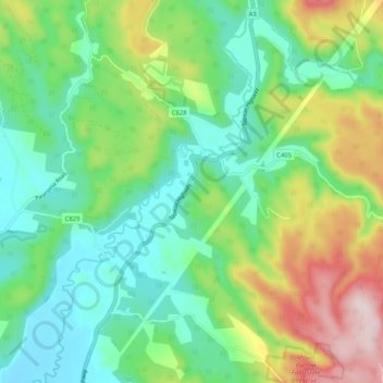
Name: Targa topographic map, elevation, terrain.
Location: Targa, City of Launceston, Tasmanie, 7259, Australie (-41.35345 147.34542 -41.28194 147.44748)
Average elevation: 495 m
Minimum elevation: 366 m
Maximum elevation: 771 m
Other topographic maps
Click on a map to view its topography, its elevation and its terrain.
Breadalbane
Australie > Tasmanie > Breadalbane
Breadalbane, Tasmanie, 7212, Australie
Average elevation: 176 m
Mole Creek Karst National Park
Australie > Tasmanie > Devonport
Mole Creek Karst National Park, Western Bluff Track, Mayberry, Devonport, Tasmanie, 7310, Australie
Average elevation: 626 m