
Skeena-Queen Charlotte topographic map
Interactive map
Click on the map to display elevation.
About this map
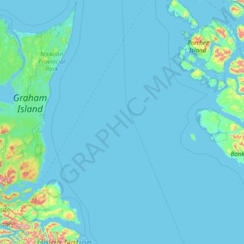
Name: Skeena-Queen Charlotte topographic map, elevation, terrain.
Location: Skeena-Queen Charlotte, Canada (52.92196 -131.87744 54.20196 -130.59744)
Average elevation: 37 m
Minimum elevation: -1 m
Maximum elevation: 1,032 m
Other topographic maps
Click on a map to view its topography, its elevation and its terrain.
Richmond Hill
Canada > Ontario > York Region
The village of Richmond Hill was incorporated by a bylaw of the York County Council on June 18, 1872, coming into effect January 1, 1873. In September 1956, the Ontario Municipal Board approved its elevation to Town status, effective January 1, 1957.
Average elevation: 256 m
Notre Dame Island
Canada > Quebec > Urban agglomeration of Montreal > Montreal
Average elevation: 14 m
Nova Scotia
Nova Scotia's topography is a diverse blend of rugged highlands, rolling hills, and fertile lowlands. The province's landscape is shaped by several upland regions, including the Southern Upland, North Mountain, and Cobequid Mountain, which are interspersed with extensive lowlands. The Southern Upland rises…
Average elevation: 41 m
Area F (Scotch Creek/Seymour Arm)
Canada > British Columbia > Columbia-Shuswap Regional District
Average elevation: 1,265 m