
Shropshire (Ceremonial) topographic map
Interactive map
Click on the map to display elevation.
Shropshire (Ceremonial)
The climate of Shropshire is moderate. Rainfall averages 760 to 1,000 mm (30 to 40 in), influenced by being in the rainshadow of the Cambrian Mountains from warm, moist frontal systems of the Atlantic Ocean which bring generally light precipitation in Autumn and Spring. The hilly areas in the south and west are much colder in the winter, due to their high elevation, they share a similar climate to that of the Welsh Marches and Mid-Wales. The flat northern plain in the north and east has a similar climate to that of the rest of the West Midlands.
About this map
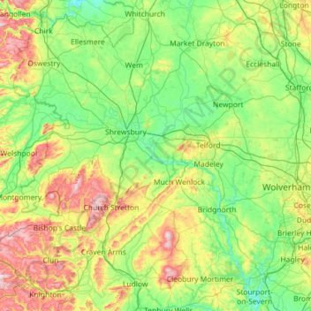
Name: Shropshire (Ceremonial) topographic map, elevation, terrain.
Location: Shropshire (Ceremonial), England, United Kingdom (52.30626 -3.23554 52.99839 -2.23290)
Average elevation: 143 m
Minimum elevation: 16 m
Maximum elevation: 541 m
Other topographic maps
Click on a map to view its topography, its elevation and its terrain.
America
United Kingdom > England > Cambridgeshire > East Cambridgeshire > Sutton
Average elevation: 7 m
Sutton Gault
United Kingdom > England > Cambridgeshire > East Cambridgeshire > Sutton
Average elevation: 5 m
Swindon
United Kingdom > England > Swindon
Swindon has an oceanic climate (Cfb in the Köppen climate classification), like the vast majority of the British Isles, with cool winters and warm summers. The nearest official weather station is RAF Lyneham, about 10 miles (16 km) west southwest of Swindon town centre. The weather station's elevation is 145…
Average elevation: 108 m
Newton Burgoland
United Kingdom > England > Leicestershire > North West Leicestershire
Average elevation: 109 m
Blackfordby
United Kingdom > England > Leicestershire > North West Leicestershire > Blackfordby
Average elevation: 135 m