
Đà Nẵng topographic map
Interactive map
Click on the map to display elevation.
About this map
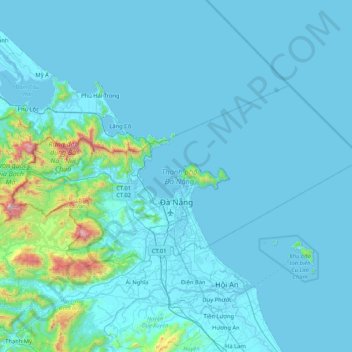
Name: Đà Nẵng topographic map, elevation, terrain.
Location: Đà Nẵng, Vietnam (15.91799 107.81854 16.33401 108.65637)
Average elevation: 99 m
Minimum elevation: -2 m
Maximum elevation: 1,662 m
Geologically, Da Nang is at the edge of a Paleozoic fold belt known as the Truong Son Orogenic Zone, whose main deformation occurred during the early Carboniferous period. Da Nang's topography is dominated by the steep Annamite mountain range to the north and north-west, which features peaks ranging from 700 to 1,500 m (2,300 to 4,900 ft) in height, and low-lying coastal plains with some salting to the south and east, with several white sand beaches along the coast.
Other topographic maps
Click on a map to view its topography, its elevation and its terrain.
Thạnh Mỹ
Vietnam > Quang Nam Province > Nam Giang District
Thạnh Mỹ, Nam Giang District, Quảng Nam Province, Vietnam
Average elevation: 182 m
Đức Hòa District
Đức Hòa District, Long An Province, 82719, Vietnam
Average elevation: 4 m
Ho Chi Minh City
Ward 15, Tan Binh District, Ho Chi Minh City, Vietnam
Average elevation: 8 m
Ho Chi Minh City
Vietnam > Ho Chi Minh City > Go Vap District
Ward 17, Go Vap District, Ho Chi Minh City, Vietnam
Average elevation: 8 m
Ho Chi Minh City
Ward 19, Binh Thanh District, Ho Chi Minh City, NGÔ TẤT TỐ, Vietnam
Average elevation: 7 m
Ho Chi Minh City
Ward 18, District 4, Ho Chi Minh City, Vietnam
Average elevation: 4 m
Kiến Giang
Vietnam > Quang Binh province > Kiến Giang
Kiến Giang, Lệ Thủy District, Quang Binh province, Vietnam
Average elevation: 3 m
Ho Chi Minh City
Vietnam > Ho Chi Minh City > Ho Chi Minh City
Ho Chi Minh City, District 1, Ho Chi Minh City, 00084, Vietnam
Average elevation: 6 m
Ho Chi Minh City
Ward 11, District 5, Ho Chi Minh City, Vietnam
Average elevation: 8 m
Ho Chi Minh City
Ward 13, District 8, Ho Chi Minh City, Vietnam
Average elevation: 6 m
Sa Pa District
Sa Pa District, Lao Cai province, Vietnam
Average elevation: 1,276 m
Phu Quoc Island
Phu Quoc Island, Phu Quoc, Phu Quoc Island, Vietnam
Average elevation: 17 m
Cần Giờ
Vietnam > Ho Chi Minh City > Ho Chi Minh City > Đông Hòa > Long Hoà
Cần Giờ, Long Hoà, Can Gio District, Ho Chi Minh City, Vietnam
Average elevation: 1 m
Côn Đảo
Vietnam > Ba Ria-Vung Tau Province
Côn Đảo, Ba Ria-Vung Tau Province, Vietnam
Average elevation: 18 m