
Ho Chi Minh City topographic map
Interactive map
Click on the map to display elevation.
Ho Chi Minh City
The city is located in the south-eastern region of Vietnam, 1,760 km (1,090 mi) south of Hanoi. The average elevation is 5 m (16 ft) above sea level for the city centre and 16 m (52 ft) for the suburb areas. It borders Tây Ninh Province and Bình Dương Province to the north, Đồng Nai Province and Bà Rịa–Vũng Tàu province to the east, Long An Province to the west, Tiền Giang Province and East Sea to the south with a coast 15 km (9 mi) long. The city covers an area of 2,095 km2 (809 sq mi or 0.63% of the surface of Vietnam), extending up to Củ Chi District (12 mi or 19 km from the Cambodian border) and down to Cần Giờ on the Eastern Sea. The distance from the northernmost point (Phú Mỹ Hưng Commune, Củ Chi District) to the southernmost one (Long Hòa Commune, Cần Giờ District) is 102 km (63 mi), and from the easternmost point (Long Bình ward, District Nine) to the westernmost one (Bình Chánh Commune, Bình Chánh District) is 47 km (29 mi). Due to its location on the Mekong Delta, the city is fringed by tidal flats that have been heavily modified for agriculture.
About this map
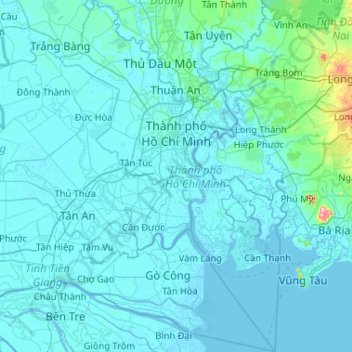
Name: Ho Chi Minh City topographic map, elevation, terrain.
Location: Ho Chi Minh City, Vietnam (10.13995 106.35670 11.16031 107.02767)
Average elevation: 17 m
Minimum elevation: -4 m
Maximum elevation: 498 m
Other topographic maps
Click on a map to view its topography, its elevation and its terrain.
Ho Chi Minh City
Ho Chi Minh City is located in the south-eastern region of Vietnam, 1,760 km (1,090 mi) south of Hanoi. The average elevation is 5 m (16 ft) above sea level for the city center and 16 m (52 ft) for the suburb areas. It borders Tây Ninh Province and Bình Dương Province to the north, Đồng Nai Province and…
Average elevation: 6 m
Mỹ Thuận
Vietnam > Bà Rịa - Vũng Tàu Province > Long Dat District > Phuoc Hai Township
Average elevation: 10 m
Quảng trường Thành phố Phan Rang-Tháp Chàm
Vietnam > Ninh Thuan province > Phan Rang – Tháp Chàm
Average elevation: 5 m
Bắc Hưng Hải River
Vietnam > Hung Yen Province > Văn Giang District > Hà Nội > Xã Bát Tràng
Average elevation: 9 m
Bản Nậm Cung
Vietnam > Lai Chau province > Phong Thổ District > Mường So Commune
Average elevation: 489 m
Thi Vai River
Vietnam > Bà Rịa - Vũng Tàu Province > Long Thành District > Phú Mỹ
Average elevation: 10 m
Hạ Long Bay
Vietnam > Quang Ninh Province > Ha Long
Due to a simultaneous combination of ideal factors such as thick, pale, grey, and strong limestone layers, which are formed by fine-grained materials; hot and moist climate and slow tectonic process as a whole; Hạ Long Bay has had a complete karst evolution for 20 million years. There are many types of karst…
Average elevation: 0 m
Sin Cowe East Island
Vietnam > Khanh Hoa province > Trường Sa District > Sinh Tồn Đông
Average elevation: 0 m
Central London Reef
Vietnam > Khanh Hoa province > Trường Sa District > Trường Sa
Average elevation: 0 m
Southwest Cay
Vietnam > Khanh Hoa province > Trường Sa District > Xã Song Tử Tây
Average elevation: 0 m