
Najran topographic map
Interactive map
Click on the map to display elevation.
About this map
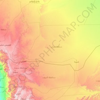
Name: Najran topographic map, elevation, terrain.
Location: Najran, Saudi Arabia (15.40000 43.06667 20.60000 48.26667)
Average elevation: 987 m
Minimum elevation: 36 m
Maximum elevation: 3,243 m
Other topographic maps
Click on a map to view its topography, its elevation and its terrain.
Saudi Arabia
Saudi Arabia's geography is dominated by the Arabian Desert, associated semi-desert and shrubland (see satellite image) and several mountain ranges and highlands. It is, in fact, a number of linked deserts and includes the 647,500 km2 (250,001 sq mi) Rub' al Khali ("Empty Quarter") in the southeastern part of…
Average elevation: 551 m
Makkah Al Mukarramah
Mecca is located in the Hejaz region, a 200 km (124 mi) wide strip of mountains separating the Nafud desert from the Red Sea. The city is situated in a valley with the same name around 70 km (44 mi) east of the port city of Jeddah. Mecca is one of the lowest cities in elevation in the Hejaz region, located at…
Average elevation: 479 m