
Free State topographic map
Interactive map
Click on the map to display elevation.
About this map
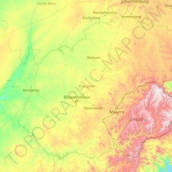
Name: Free State topographic map, elevation, terrain.
Location: Free State, South Africa (-30.69408 24.34662 -26.66874 29.78513)
Average elevation: 1,499 m
Minimum elevation: 980 m
Maximum elevation: 3,379 m
The Free State is situated on a succession of flat grassy plains sprinkled with pastureland, resting on a general elevation of 3,800 feet only broken by the occasional hill or kopje. The rich soil and pleasant climate allow for a thriving agricultural industry. With more than 30,000 farms, which produce over 70% of the country's grain, it is known locally as South Africa's breadbasket.
Other topographic maps
Click on a map to view its topography, its elevation and its terrain.
Bloemfontein
South Africa > Free State > Mangaung Metropolitan Municipality
Bloemfontein, Mangaung Metropolitan Municipality, Free State, 9300, South Africa
Average elevation: 1,374 m