
San Francisco topographic map
Interactive map
Click on the map to display elevation.
About this map
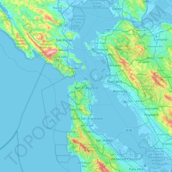
Name: San Francisco topographic map, elevation, terrain.
Location: San Francisco, California, United States (37.64031 -123.17383 37.92981 -122.28148)
Average elevation: 63 m
Minimum elevation: -5 m
Maximum elevation: 778 m
Other topographic maps
Click on a map to view its topography, its elevation and its terrain.
Groveland
United States > California > Tuolumne County
Groveland is a census-designated place (CDP) in Tuolumne County, California. Groveland sits at an elevation of 3,136 feet (956 m). The 2020 United States census reported Groveland's population was 540.
Average elevation: 898 m