
Aat topographic map
Interactive map
Click on the map to display elevation.
About this map
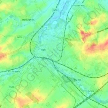
Name: Aat topographic map, elevation, terrain.
Location: Aat, Henegouwen, Wallonië, 7800, België (50.60177 3.74159 50.65600 3.82078)
Average elevation: 44 m
Minimum elevation: 24 m
Maximum elevation: 81 m
Other topographic maps
Click on a map to view its topography, its elevation and its terrain.
Mainvault
België > Henegouwen > Aat > Aat
Mainvault, Aat, Henegouwen, Wallonië, 7812, België
Average elevation: 65 m
Arbre
België > Henegouwen > Aat > Aat
Arbre, Aat, Henegouwen, Wallonië, 7811, België
Average elevation: 46 m