
Jonction topographic map
Interactive map
Click on the map to display elevation.
About this map
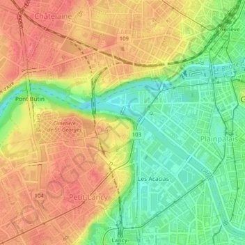
Name: Jonction topographic map, elevation, terrain.
Location: Jonction, Genève, 1200, Suisse (46.19322 6.11068 46.20513 6.14167)
Average elevation: 403 m
Minimum elevation: 367 m
Maximum elevation: 432 m
Other topographic maps
Click on a map to view its topography, its elevation and its terrain.
Petit-Saconnex et Servette
Petit-Saconnex et Servette, Genève, 1209, Suisse
Average elevation: 426 m
Parc Geisendorf
Parc Geisendorf, Grottes et Saint-Gervais, Genève, 1211, Suisse
Average elevation: 407 m